OverviewNearbyReviewsWin Prizes
Share to
Qinghai Gasiku Lake
青海尕斯庫勒湖3.3
3 Reviews
 based on 1 review
Open year round, 24/7
Recommended sightseeing time:2-3 hours
Address:
Huatugou Town, Ulan County 817100, ChinaMap
What travelers say:
The lake basin of Yuskule Lake is a closed internal flow basin, and it is recharged by the Aral River and Timur River from the Kumukule Basin in the west all year round. The surface brine area of the lake is 103km2, the water depth is 0.65m, and the lake is 2835m above sea level; the southeast of the salt lake is dry salt flat, with an area of 140km2. The geographical coordinates are 90°40 ′-91°10 ′ east longitude, 37°57 ′-38°11 ′ north longitude.
More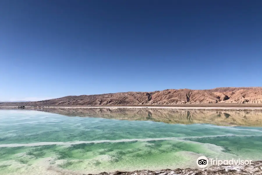
See all 3 photos
Recommendations Near Qinghai Gasiku Lake
Qinghai Gasiku Lake Reviews: Insider Insights and Visitor Experiences
Some reviews may have been translated by Google TranslateWrite a Review
 (3 Reviews)Trip.com
 (1 Reviews)TripAdvisor
/5
Average ReviewsAll (3)
Latest
With Photos (1)
Positive Reviews (1)
Negative Reviews (1)
Nearby Attractions
Mangya Emerald Lake | Aiken Spring | Huatugou Mosque | 阿拉爾河 | New Century | 瑞青網吧 | 職工文化館(前進路) | 達布遜 | 大河洗浴 | 黑泊電競 | 浪淘沙洗浴(崑崙路店) | 嘻哈桌球吧 | 行者部落越野俱樂部 | 大浪鹽浴 | 喬氏桌球俱樂部 | 藍天洗浴城 | 潔麗發藝 | 玩點回家遊戲機體驗館 | Mangya Old Age Activity Center
Popular Types of Attractions in Mangya
Popular Restaurants in Mangya
蓝锦村川菜 | 大胡子餐饮 | YuShanGgChaCanTin(QingZhen) | 张家牛杂汤(花土沟店) | 金陵灌汤包(民族路店) | 吉祥早餐 | 中秋小聚餐厅 | 家常小炒 | 炒面馆 | Tianfu Restaurant | 长香居 | 西宁东关抓面 | 好好早点屋 | 敦煌饭庄驴肉黄面 | 新疆特色餐厅 | 老妈家庭厨房 | 缘聚烤鱼庄 | Qingxianggeqingzhen Restaurant | 五谷杂粮川菜馆(前进路店) | 东乡兄弟烧烤 | 新疆沙湾大盘鸡店 | 黄焖鸡米饭 | 西北拉面馆 | 老陈烧烤 | 大团结柴火鸡(花土沟镇店) | 海比烧烤 | 川佳饭馆 | 三顾冒菜 | 茫崖牵肠挂肚市井老火锅(茫崖花土沟店) | 鸿泰面馆(昆仑路店)
Popular Destinations
Beijing Travel | Inverness Travel | Hat Yai Travel | Crete Travel | Rhodes Travel | Portugal Travel | Oxford Travel | Porto Travel | Alicante Travel | Boracay Island Travel | Cameron Highlands Travel | Bahrain Travel | Sheffield Travel | Bournemouth Travel | Chennai Travel | Perast Travel | Saudi Arabia Travel | Bosnia and Herzegovina Travel | Belgium Travel | Otago Travel | Antigua Guatemala Travel | Halton Travel | Washington County Travel | Tahoe Vista Travel | Lviv Oblast Travel | Hin Tung Travel | Mishawaka Travel | Morso Municipality Travel | Comarca Aviles Travel
Recommended Attractions at Popular Destinations
Bangkok attraction near me | Manila attraction near me | Tokyo attraction near me | Hong Kong attraction near me | Seoul attraction near me | Taipei attraction near me | Los Angeles attraction near me | New York attraction near me | Shanghai attraction near me | Kuala Lumpur attraction near me | Shenzhen attraction near me | Osaka attraction near me | Singapore attraction near me | London attraction near me | Guangzhou attraction near me | San Francisco attraction near me | Beijing attraction near me | Macau attraction near me | Bali attraction near me | Paris attraction near me | Orlando attraction near me | Jakarta attraction near me | Ho Chi Minh City attraction near me | Chicago attraction near me | Phuket attraction near me | Toronto attraction near me | Cebu attraction near me | Istanbul attraction near me | Dallas attraction near me | Seattle attraction near me
Popular Ranked Lists
Top 13 Fine Dining in Sanya | Popular Family-friendly Attractions Near Fuxin | Popular Premium Hotels Near Cajamarca | Top 20 Local Restaurants in Las Vegas | Top 14 Premium Hotels in Changbai mountain | Popular Nightlife Districts in Dublin | Popular Fine Dining in Paris | Popular Family-friendly Attractions Near Chenxi | Popular Luxury Hotels Near Kalutara | Popular Luxury Hotels Near Stradbroke Island | Top 12 Fine Dining in Changsha | Popular Premium Hotels in San Fernando | Popular Fine Dining in Hong Kong | Popular Luxury Hotels Near Ulsan | Popular Luxury Hotels Near Unna | Popular Family-friendly Attractions Near Taizhou | Top 12 Fine Dining in Kobe | Top 19 Local Restaurants in Manchester | Popular Nightlife Districts in Taipei | Popular Family-friendly Attractions Near Jingning | Popular Fine Dining in Chengdu | Top 10 Award winning restaurants in Sabah | Top 20 Premium Hotels in Madhya Pradesh | Popular Luxury Hotels Near Sipplingen | Top 20 Fine Dining in Kuala Lumpur | Top 19 Fine Dining in Rome | Popular Fine Dining in Nanjing | Top 3 Premium Hotels in Yingtan | Popular Luxury Hotels Near Ribadouro
Popular Trip Moments
Heidu Mountain, a real-life version of ink wash painting | Checked in at the Mangya Emerald Lake | The black 'Lunar Landscape' of the Great Northwest | I'm driven crazy by the unique landscapes and city characteristics of China | Qinghai self-guided tour has checked in for you | Northwest Travel | Must-Stay Hidden Gem Hotels | The desolate and rugged northwest wind - Northwest hiking guide | Mangya City: Why has it become a mysterious longing in the hearts of many travelers? | Unattainable beauty/ Crossing the desolate beauty of the Gobi Desert and Yardang | You should always visit the green apple paradise in your heart, that beautiful place deep within | The place on earth that most resembles the surface of the moon - Heidu Mountain in Qinghai! | The jade embedded in the Gobi Desert | Mangya Jade Lake | The 'salt flats and emerald waters' on the Gobi Desert | The 'Devil's Eye' Aiken Spring hidden in the Qaidam | Traveling with dogs
More Things To Do in Mangya
8-Day Qinghai Private Tour: Qinghai Lake, Chaka Salt Lake, Koluk Lake Scenic Area, Emerald Lake, Oboliang,Aiken Spring, The Water Yadan Geopark, Cangyangjiacuo Culture Square | 8-Day Qinghai Private Tour: Qinghai Lake,Chaerhan Salt Lake, The Wanzhang Salt Bridge, Kekexili National Nature Reserve, West Tignar Lake, The Water Yadan Geopark, Chaka Salt Lake | 8-Day Loop Tour in Qinghai and Gansu: Qinghai Lake, Chaka Salt Lake, Koluk Lake, West Tignar Lake, Aiken Spring,West Tignar Lake, Oboliang, Oil Town, Mogao Grottoes, Mingsha Mountain Crescent Spring | China eSIM Day Pass/data Package days selected without cards QR code | China·Hong Kong·Macau eSIM|Unlimited 4G High Speed Data | China Mainland eSIM|China Mobile Unlimited 4G High Speed Data | China, Hong Kong, and Macau eSIM|Total 5GB/10GB/15GB/20GB High-speed 4G LTE Unlimited high-speed data | Asia・Australia eSIM|AIS SIM2Fly 8 days 6GB High-speed Unlimited 5G/4G Data | [China Mainland] eSIM | SIM to China | 8GB 8days 4G high speed | Mainland China eSIM |China Mobile 4G high-speed unlimited data eSIM | Mainland China + Hong Kong + Macau eSIM 4G Data Daily Plan QR Code | Mainland China + Hong Kong + Macau eSIM Data Plan QR Code | eSender - Mainland China eSIM daily package/traffic package, days optional. No need to get the card QR code | China, Hong Kong, Macau 4G SIM Card (HK, Macau, Taiwan, China Delivery Only) | eSIM for China, Hong Kong and Macau. Universal for Mainland China/Hong Kong/Macau. Optional days for travel and business. QR code | [China, Hong Kong and Macau] 4G network | Unlimited traffic | Self-pickup at the airport | WiFi rental, high-speed traffic, shared by multiple people, ready to use at startup, 12H standby, 24H customer service | Hong Kong eSIM local - Data plan by Gohub (QR Code) | AIS Global esim data package (QR code) | China 4G SIM Card (HK, Macau, Taiwan, China Delivery Only) | [Mainland China] 4G Internet Card|China Unicom|Unlimited Data SIM Card|Number of Optional Days|Insert the card and use it|Self-pickup at Hong Kong Airport | Trip.SIM Japan, South Korea, Macau, Taiwan and many places in Asia + Australia and New Zealand 4G travel data roaming phone network card 4 days/7 days | Asia 9 Regions eSIM 4G Data Daily Plan QR Code | AIS Asia esim data package (QR code) | dtac GO INTER eSIM|Asia, Australia, USA 10Days 6GB Unlimited Data | eSender- Brunei/Indonesia/Singapore/Japan and many other countries and regions eSIM daily package/data package (QR code) | Global (30 Countries) eSIM Data Package (QR Code) | China, Macau eSIM - Data plan by Gohub (QR Code) | Global multi-region C series eSIM|Common in 84 countries Travel and business Internet access Optional unlimited data Optional days QR code | AIS SIM2Fly Global eSIM|15 days 6GB high-speed 4G/5G Unlimited Data | Global multi-region B series eSIM|Universal in 54 countries Travel and business Internet access Optional unlimited data Optional days QR code
Payment Methods
Our Partners
Copyright © 2024 Trip.com Travel Singapore Pte. Ltd. All rights reserved
Site Operator: Trip.com Travel Singapore Pte. Ltd.
Site Operator: Trip.com Travel Singapore Pte. Ltd.
The lake basin of Yuskule Lake is a closed internal flow basin, and it is recharged by the Aral River and Timur River from the Kumukule Basin in the west all year round. The surface brine area of the lake is 103km2, the water depth is 0.65m, and the lake is 2835m above sea level; the southeast of the salt lake is dry salt flat, with an area of 140km2. The geographical coordinates are 90°40 ′-91°10 ′ east longitude, 37°57 ′-38°11 ′ north longitude.
Don't go, it's closed now, foreign vehicles are not allowed to enter, you can only look at it from a distance on the national road
The little-known Mechaidam Basin of Qaidam Basin has hundreds of salt lakes, known as "Pool Pots" due to mineral abundance. In the west of Qaidam, there is a salt lake with silver edges, Lake Yuskull, also known as "Lake Yus". The lake shimmers like a mirror reflecting the snowy mountains, sky, and white clouds. The lake is surrounded by a circle of salt belts, as if it is a mysterious land fingerprint. #Traveling after the Spring Festival #Is it snowing in your hometown #Traveling around with peace of mind #Where to go in winter #Walking the baby behavior reward