OverviewBookNearbyReviewsWin PrizesRecommended
Share to
Sejila Mountain
色季拉山5.0
206 Reviews
 based on 9 reviews
Open year round, 24/7
Recommended sightseeing time:1 hour
Address:
Within Bayi District, Nyingchi City (East side of Nyingchi Town)Map
What travelers say:
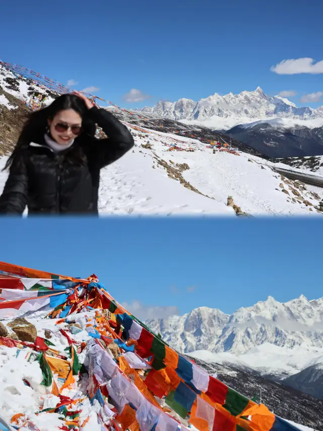
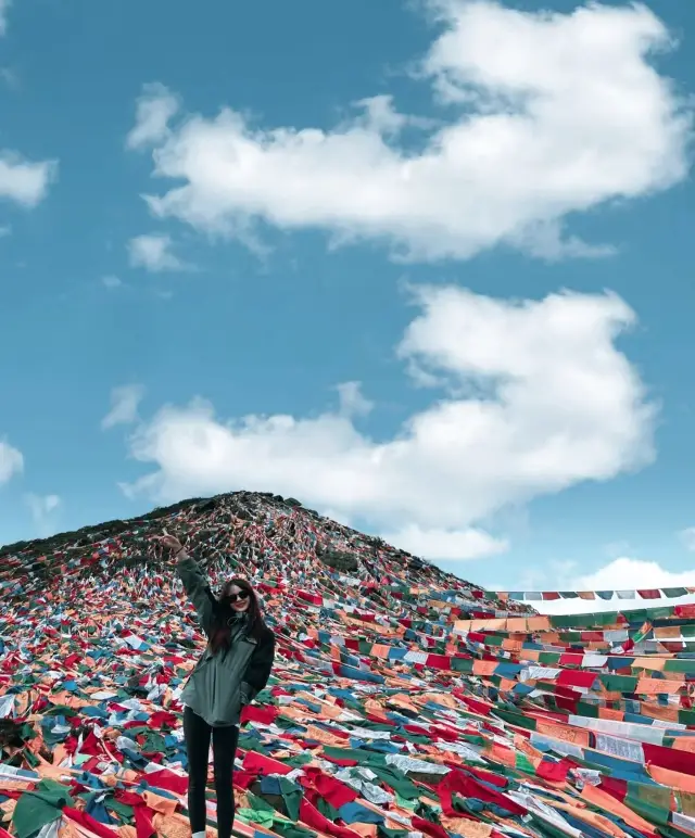
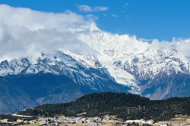
Sejila Mountain is located east of Nyingchi County, Tibet. It is a famous landmark on the Sichuan-Tibet line. The mountain pass is 4,720 meters above sea level and has a wide view. You can overlook the Lulang Linhai and the Nanga Bawa Peak behind it. The colorful scriptures of the mountain pass are fluttering in the wind and the scenery is beautiful.
More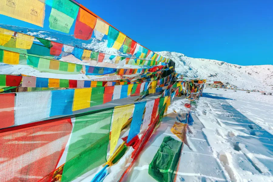
See all 2 photos
Saved by 5
Sejila Mountain Highlights: Must-See Features and Attractions
Some information may have been translated by Google Translate
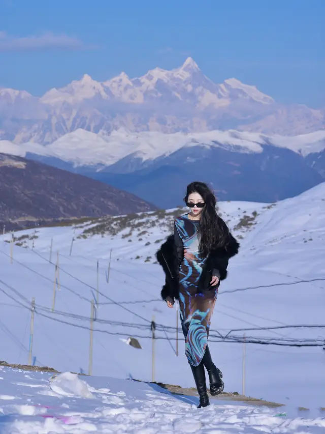
Sejila Mountain is located on the southeast side of Bayi Town. When walking on the Sichuan-Tibet line, Bomi will pass by on the Bayi Road. It is a famous landmark on the Sichuan-Tibet line. The Sejila Mountain Pass is 4,728 meters above sea level, with a wide field of vision. You can overlook the Lulang Forest Sea and the Nanga Bawa Peak behind it. It is a good place to take pictures. The rhododendrons all over the mountains are also a famous landscape of Sejila Mountain. From April to June every year, from the foot of the mountain to the mountainside, as many as two dozen kinds of rhododendrons gradually bloom in the mountains, with various colors and shapes, bright and dazzling. Combined with the colorful prayer flags flying in the mountain pass, the scenery is gorgeous. When tourists pass by, they will inevitably stop and watch.
Recommendations Near Sejila Mountain
Sejila Mountain Reviews: Insider Insights and Visitor Experiences
Some reviews may have been translated by Google TranslateWrite a Review
 (206 Reviews)Trip.com(9 Reviews)TripAdvisor
/5
Outstanding ReviewsAll (206)
Latest
With Photos (171)
Positive Reviews (105)
Negative Reviews (1)
- 1
- 2
- 3
- 4
- 42
Sejila Mountain Photos: Trip Moments
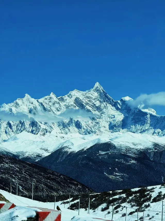 I am viewing Mount Namjagbarwa from the Sejila Mountain PassThe Sejila Mountain Pass is a place on the way from Bayi Town in Nyingchi to Bomi County, also located on National Highway 318. It is a famous landmark and arguably the best spot to view Mount Namjagbarwa, as long as the weather is clear. From here, one can see the full splendor of this most beautiful peak. The ox head bell and the prayer flags spread across the mountains are the most significant symbols of the Sejila Mountain Pass. The Sejila Mountain Pass is also known for its unique alpine rhododendrons, including the rare black rhododendrons, which bloom from mid-April to June. The mountainside covered with rhododendrons is incredibly beautiful and marks the best season to visit the Sejila Mountain Pass. The drive from Bayi Town in Nyingchi to the Sejila Mountain Pass takes about an hour. There is no public transportation available, so it is recommended to drive or join a tour group. However, the road is at a high altitude with many bends, so one must drive with extra caution.quellis_0314
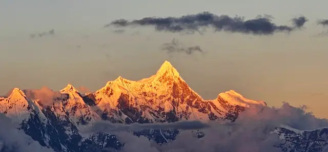 We witnessed the golden sunrise on Mount Namjagbarwa at the free viewing spotFree viewing spot. Mount Namjagbarwa is the highest mountain in Nyingchi, Tibet, with an elevation of 7782 meters, part of the Himalayas. Its massive triangular peak is covered with snow all year round and shrouded in clouds and mist, making it elusive and often referred to as 'Shy Girl Peak'. The golden sunrise on Mount Namjagbarwa is even rarer to encounter, especially during the season we visited. However, we were lucky. After visiting Lulang and on our way to Nyingchi, we thought we'd stop by, and unexpectedly, we saw it on our first try. It was very cold that day, but the atmosphere was great. A group of strangers gathered together at the Sejila Mountain Pass, nearly 5000 meters above sea level, our hands and mouths almost numb from the cold, ready to descend the mountain, and in an instant, as we turned around, we saw it (it appeared around 7:50 pm and lasted for about 15-20 minutes) - the golden sunrise on Mount Namjagbarwa!! Everyone couldn't help but cheer, the shouts echoed from the mountain top to the bottom, some were loudly venting, making wishes, and at that moment, as we looked at each other, I believe everyone had different thoughts, but the same feeling was: squatting for hours was worth it, and that moment felt warm on the 318 road because of the responding cheers Little tips: 1. Navigate to Sejila Mountain Pass, park at the roadside of the viewing platform (free), and the Sejila Mountain is right across the road, with a great spot for photography. However, it is very cold due to the high altitude, so remember to wear more, otherwise, you will really freeze, and those with altitude sickness should be cautious, as the mountain is difficult to climb (refer to the last two photos). You can also see the golden sunrise from the viewing spot (that day we wore base layers + down jackets + hardshell jackets and it was still cold). 2. The Sejila Mountain area is free, I'm not sure if it's because September is the off-season or if it's always free, other places like Sosong Village have been fenced off and charge a fee, so you can choose your location accordingly. 3. Remember to hold onto the prayer flag ropes when climbing the mountain, it's much easier and safer. Also, two-thirds of the way up the mountain is about right, there's a flatter spot where you can sit, rest, and set up a tripod. You can't go to the very top later, as staff will usher you away. Finally, I wish everyone good luck and hope you all get to experience itPenelopeRivera.47
 Complete Travel Guide to the Peach Blossom Festival in Nyingchi, Tibet! It was so impressive!I recently went on a 6-day tour to Tibet! The main purpose was to see the peach blossoms in Nyingchi! But I went a bit early, and the peach blossoms were not in full bloom yet, though they were still beautiful! I've organized this guide for you! You can boldly and confidently go for it! Nyingchi: After arriving in Nyingchi, you can take some time to acclimate to the high-altitude climate. Rest flat in the hotel. Friends with good physical condition can also go to the center of Nyingchi city for a walk after landing! Bomigala Peach Blossom Village: This place is a famous peach blossom spot in Nyingchi~ Surrounded by mountains on three sides, the peach blossoms look incomparably beautiful against the backdrop of snow-capped mountains🏔️ and forests. Mid-March to mid-April is the peach blossom season in Nyingchi, so those who love peach blossoms under the snow mountains should remember to plan their time well! Sejila Mountain Pass: The scenery along the way is really too stunning, with the snow-capped mountains and the heavy snowfall, it's breathtaking! After reaching the Sejila Mountain Pass, you can look far into one of China's most beautiful peaks→Namcha Barwa! I'm really lucky! To be able to witness the beauty of the peak! It's an unforgettable experience in this lifetime Guoxiang Lake: This place really surprised me, it's a relatively lesser-known lake, but the water is clear and green, with several tall trees standing erect in the middle of the lake. Surrounded by the green water and snow-capped mountains🏔️, it gives the beautiful illusion of being transported to New Zealand~ Bomi Peach Blossom Valley: Because we came early, the peach blossoms were not fully in bloom, but it had its own unique charm! This is where Peach Blossom Valley is, friends who like peach blossoms can wait for the weather to warm up a bit more before coming! Basong Lake: You can take a leisurely stroll, look at the lake, see the snow mountains, or choose to take a boat to enjoy the feeling of being surrounded by snow mountains~ This place is known as the 'Little Switzerland' of Tibet~ Lhasa: The last stop is Lhasa!! Since I've fully adapted to the high-altitude environment, there were no altitude sickness issues during the entire trip, and I ate and slept well~ In Lhasa, you can go for a city walk. These are some places you can choose to visit! →Barkhor Street: A place for prayer and a commercial center →Yaowang Mountain Viewing Platform: Remember to bring 50 RMB →Potala Palace, Jokhang Temple: No need to say much about these two places!!! →Sera Monastery, Zaki Temple I was on a group tour for the entire trip, and it was a pure play team, plus all the teammates were young people, so we had a great time together! The key is that I met many like-minded friends!!! Tibet! I will come again!Casandra Bauch
 Tibet Five-Day Loop | This one article is enough for the itineraryI went to Tibet during the Spring Festival, and many people asked me about this trip's itinerary when I posted on my Moments 🙈 so I organized these notes. Friends who need it can like and save it oh 👍 🌟【Winter Tour of Tibet - Lagu Glacier 5-Day Tour Itinerary】 Day1️⃣: Lhasa-Basumtso-Linzhi (Attraction: Basumtso) Day2️⃣: Linzhi-Sejila Mountain Viewing Platform-Ranwu Lake-Ranwu Town (Attractions: Sejila Mountain+Ranwu Lake) Day3️⃣: Ranwu Town-Lagu Glacier-Bomi (Attraction: Lagu Glacier) Day4️⃣: Bomi-Niyang River Scenic Area-Namcha Barwa Peak Sunlight Golden Mountain-Sosong Village (Attraction: Namcha Barwa Peak) Day5️⃣: Sosong Village-Buddha Palm Sand Dunes-Lhasa (Attractions: Buddha Palm Sand Dunes, the spectacular dunes embraced by glaciers and the Yarlung Tsangpo River) ⚠️【Some travel tips】 1️⃣Lhasa is at an altitude of 3600 meters, Linzhi is slightly lower, and has more vegetation coverage, so you can take a series of actions such as bathing and washing hair in Linzhi~ 2️⃣The altitude of this trip is mostly around 3200-4500 meters, and the accommodations are all around 3000+ meters 3️⃣The daily drive is about 5 hours, which is quite long, so it's suggested to prepare some snacks in the car~ 4️⃣Lagu Glacier can be visited from December to March, it is recommended to go in the morning❗️ The ice may melt a bit in the afternoon~ The wind at Lagu is quite strong, remember to wear a hat 🧢 5️⃣In winter, it's easiest to see the Namcha Barwa Peak Sunlight Golden Mountain from Sosong Village, because there is less rain and lower humidity~ExploreWithPassion1
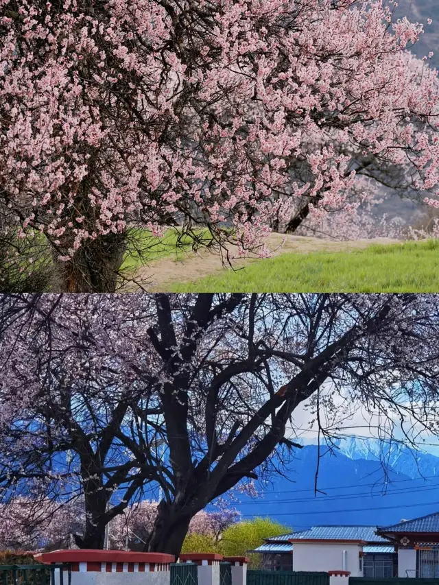 Those planning to visit Tibet to see the peach blossoms in March-April, heed my advice!The beauty of Tibet can heal a lifetime, and one day, you will set foot on this vast land for any reason ⛳. March-April is the last off-peak period in Tibet, after which the crowded peak season begins. Not only are there fewer tourists and lower costs in March-April, but you can also witness the annual spring spectacle of miles of peach blossoms 🌸. Here comes the flower viewing guide · ✅ Transportation Guide ✈ Plane: Direct flights to Lhasa or Nyingchi 🚞 Train: Lhasa-Nyingchi (train numbers C881/C893, about 4H journey) · The main venue for the Peach Blossom Festival is Gala Peach Blossom Village 🏕, and other flower viewing spots include: ❶ Peach Blossom Valley and Gala Village in Bomi Town; ❷ Gala Village in Nyingchi Town; ❸ Zhuo Village and Bajie Village in Lang County; ❹ La Ru Village in Basum Co; ❺ Suosong Village · Since the peach blossoms are mostly in Nyingchi, it's best to choose the Nyingchi route. Moreover, Nyingchi is at a relatively lower altitude with rich vegetation 🌳, hence higher oxygen content and less chance of altitude sickness, making it very suitable for those visiting Tibet for the first time. Here's a quick look at the itinerary 👇 day1: Lhasa--Basum Co--Nyingchi--Sejila Mountain Pass--Lulang Forest Sea--Stay in Lulang Town day2: Lulang Town--Peach Blossom Valley--Ranwu Lake--Laigu Glacier--Stay in Bomi day3: Bomi--Guxiang Lake-Lulang--Nyingchi--Yarlung Tsangpo Grand Canyon--Stay in Suosong Village day4: Suosong Village--Kading Valley--Gongdelin Grassland--Qinhou Platform or Shannan Museum--Stay in Zedang day5: Zedang--Yamdrok Lake--End in Lhasa · 💼 Packing List 🔻 Documents: Student ID, ID card, and other concessionary documents 🔻 Clothing: Scarf 🧣, gloves, sunglasses, mask, hat, down jacket, hoodie, windbreaker, fleece pants, lightweight sports shoes 🔻 Others: Power bank, thermos, compressed snacks, disposable bath towels, toilet seat covers, wet wipes, common medicines 🔻 Skincare: Moisturizing toner and lotion, face masks, lip balm, face cream, cosmetics (avoid tube packaging) ·Owen Young
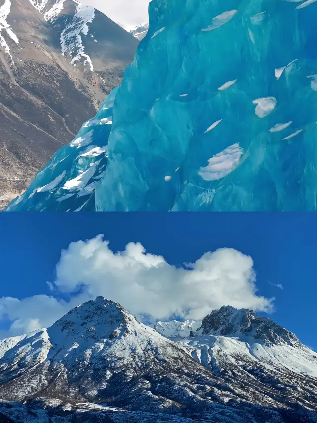 Tibet Nyingchi - Laigu Glacier 5 days 4 nights ultimate adventure tour!🌟Explore Nyingchi-Laigu Glacier: A five-day and four-night encounter with the pure snow mountain🏔️ 💥Tibet, that mysterious land, is fascinating. And Nyingchi-Laigu Glacier is even more of a dazzling gem in it. Standing on top of the glacier, it seems as if the whole world has come to a standstill, with only the snow mountain, blue sky, and you. The five-day and four-night itinerary will take you deep into this fairyland on earth. 📅Itinerary: 📍Day 1: Lhasa - Sejila Mountain - Lulang Forest Sea Hiking in Lulang Forest Sea, feel the freshness and tranquility of nature. 📍Day 2: Lulang - Bomi - Ranwu Lake The quiet beauty of Ranwu Lake seems to wash away all the dust. 📍Day 3: Ranwu - Laigu Glacier/Renlongba Glacier - Bomi Visit the mysterious glacier and feel the pure breath from the snow mountain. 📍Day 4: Bomi - Yarlung Zangbo River Grand Canyon - Suosong Village Hiking in the Yarlung Zangbo Grand Canyon, get close to nature. 📍Day 5: Suosong Village - Basongtso - Lhasa End the wonderful journey and return to Lhasa with full memories. 💡Highlights of the trip: ✅Deeply visit Nyingchi city area, feel the unique charm of Tibetan culture. ✅Climb up Namjagbarwa Peak, overlooking the beautiful scenery of Nyingchi area. ✅Specially arranged to stay in local characteristic homestays, taste authentic Tibetan food. ✅Professional guides accompany you throughout the journey, interpreting the thousand-year history and culture of this land for you. ✅Aerial photography + SLR camera follow-up, leave your exclusive image. ✅Four-wheel drive off-road vehicle ensures a safer journey. 📌Preparation before departure: 🥶It is recommended to bring warm clothes, sunscreen, sun hat, etc. 🩹Prepare common medicines in case of high altitude sickness or other emergencies. 📷Bring a camera to record these rare beautiful moments. Are you ready for the five-day and four-night magical journey? Let's step into Nyingchi-Laigu Glacier together and feel the pure land and amazing scenery!✨Samuel.Rivera.74
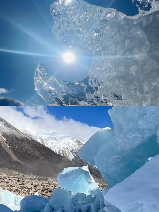 5 Days 4 Nights In-depth Tour to Laigu Glacier: A Trip to Nyingchi, Tibet, Exploring the Story Behind the Glacier!Nyingchi, Tibet - Laigu Glacier 5 Days 4 Nights In-depth Tour🚀 ✨Tibet, a land that fascinates people🏞️, and Nyingchi—Laigu Glacier is the dazzling gem in it✨. Standing on top of the glacier, it seems that the whole world has stopped, only the snow mountain is with you🏔️. ✨5 days and 4 nights, let's delve into this mysterious land and feel the stunning scenery of Nyingchi—Laigu Glacier. 📌Itinerary: 1️⃣Lhasa-Sejila Mountain-Lulang🏞️ Arrive in Lhasa on the first day, rest a bit and then head to Sejila Mountain to enjoy the beautiful scenery of Nyingchi. Then go to Lulang to experience the perfect combination of Tibetan culture and natural landscape. 2️⃣Lulang-Bomi-Ranwu🏞️ Start in the morning to Bomi, pass through the primitive forest on the way, and enjoy the unique Tibetan villages. After arriving in Ranwu, you can choose to stroll by the lake and feel the tranquility and beauty. 3️⃣Ranwu-Laigu Glacier/Renlongba Glacier-Bomi🏞️ After breakfast, we will go to Laigu Glacier or Renlongba Glacier to feel the grandeur and purity of the glacier. Return to Bomi in the evening to end a fulfilling day. 4️⃣Bomi-Yarlung Zangbo Grand Canyon-Sosong Village🏞️ Today we will hike to explore the Yarlung Zangbo Grand Canyon and feel the charm of nature. Then go to Sosong Village to enjoy the tranquility and beautiful scenery there. 5️⃣Sosong Village-Basongtso-Lhasa🏞️ On the last day, we will go to Basongtso to enjoy the lake and mountain scenery there. End the pleasant journey and return to Lhasa. ✨Highlights of the trip: ✅Deeply visit Nyingchi city area to feel the unique charm of Tibetan culture🎤. ✅Hike to explore the Yarlung Zangbo Grand Canyon and get close to nature🌿. ✅Climb up to Namjagbarwa Peak and overlook the beautiful scenery of the entire Nyingchi area🌄. ✅Stay in local characteristic homestays and taste authentic Tibetan food🍲. ✅Professional guides accompany you throughout the journey, interpreting thousands of years of history and culture📜. ✅Drone aerial photography + SLR camera follow-up📷. ✅Four-wheel drive off-road vehicle ensures a safer journey🚜. ✨Preparation before departure: 🥾It is recommended to bring warm clothes, sunscreen, sun hats, etc.👒. 📷Bring a camera to record these rare beautiful moments📸. 💊Prepare common medicines in case of altitude sickness or other emergencies💊.SeekerOfWander
 Sejila Mountain - Travel Guide▲Overview Sejila Mountain is located on the southeast side of Bayi Town. When traveling on the Sichuan-Tibet line, you will pass through here on the way from Bomi to Dao Ba - it is also one of the famous landmarks on the Sichuan-Tibet line. The Sejila Mountain Pass is 4728 meters above sea level. When you climb to the pass, the view is wide. You can see the Lulang Forest Sea and the Namjagbarwa Peak behind it. It is an excellent place for taking pictures. The azaleas scattered throughout the mountains are also a famous sight of Sejila Mountain. They bloom from April to June every year, gradually opening, dazzling and diverse, very beautiful. ●Best season Plateau mountain climate; suitable for all seasons ( ) Suggested play Sejila Mountain Pass; 1 hour ⑤Consumption level Moderate National ticket Free ●Opening hours All dayThe Gourmet Explorer
 Tibet Sejila Pass | Looking up at Namjagbarwa Peak 7782 meters| Looking up at Namjagbarwa Peak 7782 meters. 🌟🌟🌟Self-driving from Chongqing to Lhasa, passing through the Sejila Pass, just in the early morning, had the opportunity to witness the spectacular Namjagbarwa Peak, the altitude of 7782 meters, awe-inspiring, it's too beautiful, Namjagbarwa Peak under the sea of clouds, with the morning sun, there are many tourists, all raising their cameras to take pictures. 🌟🌟🌟The Sejila Mountain Pass is located to the east of Linzhi County in Tibet, crossing the pass on National Highway 318. The self-driving vehicle stopped at the junction at an altitude of 4728 meters, which is also the best photography point for Namjagbarwa Peak. Sunrise, sea of clouds, forest sea, mountain peaks, all of this is super beautiful. 🌟🌟🌟The bull's head on the Sejila Mountain is very conspicuous, it is said that the shape symbolizes good luck and is used to pray for peace and good luck. The conspicuous 7782 meters sign next to the bull's head bell, let's ring the bull's head bell together, pray for the blessing of the mountain god on Namjagbarwa Peak.PassionateNomad
 Kawagebo - Namjagbarwa🚗🚗🚗Travel route: Day1: Shangri-La Dukezong → Feilai Temple Day2: Feilai Temple → Shuo Da Village - Xueda Lake → Wunong Peak Day3: Wunong Peak → Bingzhongluo → Chawalong Township Day4: Chawalong Township → Chayu County Day5: Chayu County → Ranwu Town → Laigu/Yalong Glacier Day6: Ranwu Town → Lulang Dongba Cai Village → Baifeng Platform Day7: Dongba Cai Village → Suosong Village → Dalin Village Day8: Suosong Village → Milin Airport / LhasaThe Wandering Gourmand1
Nearby Attractions
Cuomujiri Scenic Area | Kading Tianfo Pubu Forest Scenic Area | Yani Wetland Scenic Area | World Cypress King Garden | Yarlong Tsangpo River | 雅尼國家濕地公園 | Niyang Scenery | Nyingchi Ziran Museum | Gala Peach Blossom Village | Kadinggou Tianfo Waterfall | Birishenshan Ecological Scenic Area | Giant Cypress Nature Reserve of Bajie, Nyingchi | River Confluence | 林芝市巴宜區林芝鎮真巴村 | Oriental Coast Hot Spring | Lamalin Temple of Bujiu | FuLin Jie | Sejila National Forest Park | Maoniu Square | First Tibetan Folk Village | Niyangge Southeast Tibet Cultural Expo Park | 工布原鄉景區 | Fujian Park | Cang Dongnan Wenhua Yichan Museum | Millennium Walnut King Folk Culture Village | Benri Mountain | Kasimucun | 西藏雅尼國家濕地公園 | Daze Village | Linhai
Popular Types of Attractions in Nyingchi
Popular Restaurants in Nyingchi
Lulangshiguocheng·songrongjunshiguo Chicken | 盐帮菌王府(林芝总店) | 酸叔老坛酸菜鸡(波密分店) | SHENG DE ZHUO LONG CANG GU YAN | 兰心石锅菌王府(林芝佳美花园店) | 南渝食府.石锅鸡(尚城花园店) | 鲁朗小涛石锅美食城 | 鲁朗纳麦石锅鸡庄园 | 滋补菌石锅居 松茸石锅鸡 | 知味轩石锅鸡 | 林芝后客东来酒店·后知咖啡 | Yilaoliuqiaojiaoniuroufeiwuzhiwenhuayichan | 松茸石锅鸡 | TAOHUAYUN | 小奕菜馆 | 寓见花园餐厅 | 德庆林厨房 | 扎西德勒藏餐馆 | 广东顺德饭店 | Shuaige Restaurant | 津典新津青菜园子(林芝琅赛花园店) | 工布石锅(波密分店) | 高源·牦牛肉·石锅串串 | Evergrande Café | Jialabaileizhong Restaurant | 工布厨房 | 拉萨鲁布藏面馆 | 啦咧思藏餐厅 | 仁青客栈 | 朋源石锅酸汤牦牛肉
Popular Destinations
Recommended Attractions at Popular Destinations
Bangkok attraction near me | Tokyo attraction near me | Manila attraction near me | Hong Kong attraction near me | Taipei attraction near me | Seoul attraction near me | Los Angeles attraction near me | New York attraction near me | Shanghai attraction near me | Kuala Lumpur attraction near me | Osaka attraction near me | Shenzhen attraction near me | Singapore attraction near me | London attraction near me | Guangzhou attraction near me | San Francisco attraction near me | Beijing attraction near me | Macau attraction near me | Bali attraction near me | Paris attraction near me | Ho Chi Minh City attraction near me | Orlando attraction near me | Jakarta attraction near me | Chicago attraction near me | Phuket attraction near me | Toronto attraction near me | Fukuoka attraction near me | Istanbul attraction near me | Dallas attraction near me | Cebu attraction near me
Popular Trip Moments
Crossing the Yarlung Zangbo Grand Canyon, explore the last "Lotus Holy Land" in Tibet | Basum Tso is a must-see, it's so beautiful | Make Nyingchi your first stop when you come to Tibet! | Nyingchi Hotel Recommendation | Tingyue Guantang | The winter Namtso can cure everything! | Is Motuo, recommended by Hu Ge, really worth visiting? | Yarlung Zangbo Grand Canyon (Part I) | I thought the peach blossoms in Linzhi were beautiful until I visited the ones in Bomi | Capturing Fairy Tale Scenes | No Need to Go to Suosong Village for Peach Blossoms in Nyingchi Anymore | At the foot of Mount Namjagbarwa, attend a 'Peach Blossom Appointment' | Is Motuo, recommended by Hu Ge, really worth visiting? | Use the blue of the sky and the pink of the cherry blossoms to add the most beautiful touch to your own birthday | Medog Travel Guide!!! | Encounter the Most Beautiful Spring in China 2024, Peach Blossoms in Tibet! | It is really very beautiful | Tibet is a Shangri-La, fallen into the snowy secret realm of Nyingchi's Sygera Mountain | A long journey dedicated to the distant lands | Please keep this Sichuan-Tibet travel guide well | Thanks to Wozji for recommending the Taohua Hotel in Linzhi | Do not come to Sosong Village in Linzhi, Tibet! Otherwise | Tibet Nyingchi | The Songzan Basongtso Linka Hotel is just too photogenic | Nyingchi, Tibet - Wild Peach Blossoms Under the Snowy Mountains | Travel during the National Day holiday and explore the magical land of Tibet! | Galongla | I was shocked before even reaching Motuo | Upon arriving in Zayü County, Tibet, it finally felt a bit lively | Gala Village | Encountering the Most Beautiful Peach Blossoms Beneath the Snowy Mountains | Zajia Gou | Another paradise that makes one forget about home - the Lulang Forest, no need to pretend you're in Switzerland! | I am viewing Mount Namjagbarwa from the Sejila Mountain Pass | Songzan Namjagbarwa Mountain Residence | A uniquely beautiful hotel that cannot be replicated
Popular Travel Types
More Things To Do in Nyingchi
4-Day Lhasa to Nyingchi Private Tour: Pagsom Co, Lamulacuo, Yamdrok Lake | 3-Day Tibet Private Tour: Namcha Barwa Peak, Kading Valley, Yarlung Zangbo Grand Canyon | 6-Day Small Group Lhasa, Yamdrok and Shigatse Tour from Shenzhen | 8-Day Small Group Lhasa,Everest Base Camp and Yamdrotso Lake Tour from Nanjing | 8-Day Small Group Lhasa, Everest Base Camp and Yamdrotso Lake Tour from Kunming | 6-Day Small Group Lhasa, Yamdrok and Shigatse Tour from Guangzhou | 8-Day Small Group Lhasa, Everest Base Camp and Yamdrotso Lake Tour from Tianjin | 8-Day Small Group Lhasa, Everest Base Camp and Yamdrotso Lake Tour from Dalian | 6-Day Small Group Lhasa, Yamdrok and Shigatse Tour from Beijing | 8-Day Small Group Lhasa, Everest Base Camp and Yamdrotso Lake Tour from Harbin | 8-Day Small Group Lhasa,EverestBaseCamp and Yamdrotso Lake Tour from Zhangjiajie | 6-Day Small Group Lhasa, Yamdrok and Shigatse Tour from Xi'an | 6-Day Small Group Lhasa, Yamdrok and Shigatse Tour from Chongqing | 8-Day Small Group Lhasa,Everest Base Camp and Yamdrotso Lake Tour from Chengdu | 8-Day Small Group Lhasa, Everest Base Camp and Yamdrotso Lake Tour from Qingdao | 8-Day Small Group Lhasa, Everest Base Camp and Yamdrotso Lake Tour from Shanghai | Explore Tibet: 5-Day from Lhasa to Shigatse | 6-Day Small Group Lhasa, Yamdrok and Shigatse Tour from Chengdu | 8-Day Small Group Lhasa, Everest Base Camp and Yamdrotso Lake Tour from Beijing | 8-Day Small Group Lhasa,Everest Base Camp and Yamdrotso Lake Tour from Guiyang | 8-Day Small Group Lhasa,Everest Base Camp and Yamdrotso Lake Tour from Suzhou | 8-Day Small Group Lhasa,Everest Base Camp and Yamdrotso Lake Tour from Hangzhou | 8-Day Small Group Lhasa,Everest Base Camp and Yamdrotso Lake Tour from Guangzhou | 8-Day Small Group Lhasa,Everest Base Camp and Yamdrotso Lake Tour from Sanya | 8-Day Small Group Lhasa, Yamdrotso Lake and Everest Base Camp Tour | 8-Day Small Group Lhasa,Everest Base Camp and Yamdrotso Lake Tour from Chongqing | 6-Day Private Tour from Lhasa to Tsedang in Tibet | 4-Day Explore Lhasa Private Tour | 6-Day Small Group Lhasa, Yamdrok Lake and Shigatse City Tour | 6-Day Small Group Lhasa, Yamdrok and Shigatse Tour from Shanghai
Payment Methods
Our Partners
Copyright © 2024 Trip.com Travel Singapore Pte. Ltd. All rights reserved
Site Operator: Trip.com Travel Singapore Pte. Ltd.
Site Operator: Trip.com Travel Singapore Pte. Ltd.
Sejila Mountain is located east of Nyingchi County, Tibet. It is a famous landmark on the Sichuan-Tibet line. The mountain pass is 4,720 meters above sea level and has a wide view. You can overlook the Lulang Linhai and the Nanga Bawa Peak behind it. The colorful scriptures of the mountain pass are fluttering in the wind and the scenery is beautiful.
20220607 In the afternoon: 1. There is no bus in the scenic spot, and you need to drive along National Highway 318. The Sejila Mountain Forest and Plant Resources are rich in animal and plant resources, and there are 25 kinds of animals protected at the national level, but they are all hidden in the deep mountains, and they must not be seen by the 318 National Highway. 2, "Niyang Scenery" stone monument is the first photo point, from the mountains down overlooking the Niyang River, yellow and green fields, the blue sky and white clouds in the distance constitute the beautiful picture, the stone monument has a food and drink can be replenished. 3. Going forward is the "Sejila Pass" at an altitude of 4782 meters, which is the main landscape platform of the forest park. Self-driving tours will park here to view the scenery. The Nanga Bawa peak at 7782 meters above sea level (the 28th peak in the world, commonly known as the "ten times and nine times" Shenshan: 90% of the time in a year is surrounded by clouds and mist. Only more than 30 days will cloud and fog to see the true face). 4. The landscape platform is not large in size, and the center is a bull head clock. Tourists take turns to ring the clock to take pictures, and there are also tour anchors on the live broadcast. There are several stone piles with colorful scriptures next to the clock that are also photo spots. Some stones are piled on the hillside. I just went to Tibet to climb up and couldn't help but slow down and gasp. The elderly tourists have a strong altitude sickness and are not recommended to climb. 5, science, and then forward Lulang Town and Lulang Linhai are also within the scope of Sejila National Forest Park, but also as a scenic spot for commercial development.
Sedila Mountain is a Nianqing Tanggula Mountains, is the boundary belt between the eastern and central west of Nyingchi County, Tibet, is the watershed between the Niyang River Basin and the Palong Zangbo River, and is crossed by the southern line of the Sichuan-Tibet Highway. Climbing at an altitude of 4,728 meters, you can see the sunrise, the sea of clouds, the endless forest sea and the magnificent beauty of the Nanga Bawa Peak. There are many vegetation here, including beautiful flowers, many are perennial flowers, do not pick and destroy at will.
The famous attractions on the Sichuan-Tibet Highway can overlook the Nanga Bawa Peak. It is indeed exciting to come to this place.
It is worth seeing a place. We first went to Sejila Mountain. On the way, we encountered heavy snow. The Sejila Mountain in the snow has a special flavor. Then taste Lulang's stone pot chicken. It is indeed a rare experience to watch the sky flying snow and listen to the bursts of Songtao. Friends who go to self-driving tour must prepare more clothes. According to local friends, it is raining in the summer, and it may snow on the mountain. In addition, the non-slip chain is the most effective safety protection measure. You can prepare in front of the mountain just in case.
It's cold, but the beautiful scenery makes up for the suffering