Cape Spartel
 based on 900 reviews
Cape Spater is located in the northwestmost part of the African continent, with a sea level of more than 300 meters, overlooking the sea. There are two towers on the Cape, mainly used as lighthouses and serving ships, which are iconic. There is a cave below the promontory, with a long history, archaeologists found the remains of the Neolithic era, and later the rocks next to the cave were constantly mined, which finally made the cave larger and larger, and became the current scale. In fact, there were many major historical events at Cape Spalter: the American War of Independence in 1782, and the British and French fleets at sea not far away. The Spanish Civil War of 1936, when it was a contest between nationalism and the Republic's fleet, finally breaking the Republic's blockade of the Strait of Gibraltar, ensuring that the naval supply route for Spain and Morocco at the beginning of the war was west of the Atlantic Ocean, The eastern side connects the Mediterranean. A pure white lighthouse stands alone on the cliff edge of the promontory, like a vigilant in traditional Moroccan costumes and oil lamps. This pattern is on the back of a note that has been guiding the ships passing here for centuries to the 200 dirham face value. Explain the importance of this inconspicuous small lighthouse address: 1.14km Achakar commun de Tanger, 90000 Moroccan Transportation: There is no public transportation in this place. If you are not driving by yourself, come before chartering a car. Come and go with the African hole for 250 dirhams. The time price is about 175 yuan. Every attraction will wait for you to take pictures for a while. Three hours is enough.
More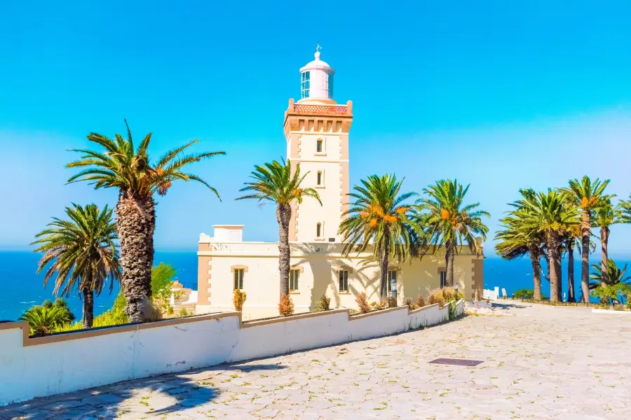
Cape Spartel Highlights: Must-See Features and Attractions
Recommendations Near Cape Spartel
Cape Spartel Reviews: Insider Insights and Visitor Experiences
Some reviews may have been translated by Google Translate (52 Reviews)Trip.com
 (900 Reviews)TripAdvisor
- 1
- 2
- 3
- 4
- 11
Nearby Attractions
Popular Types of Attractions in Tangier
Popular Restaurants in Tangier
Popular Destinations
Recommended Attractions at Popular Destinations
Popular Trip Moments
Popular Travel Types
More Things To Do in Tangier
Site Operator: Trip.com Travel Singapore Pte. Ltd.
Cape Spater is located in the northwestmost part of the African continent, with a sea level of more than 300 meters, overlooking the sea. There are two towers on the Cape, mainly used as lighthouses and serving ships, which are iconic. There is a cave below the promontory, with a long history, archaeologists found the remains of the Neolithic era, and later the rocks next to the cave were constantly mined, which finally made the cave larger and larger, and became the current scale. In fact, there were many major historical events at Cape Spalter: the American War of Independence in 1782, and the British and French fleets at sea not far away. The Spanish Civil War of 1936, when it was a contest between nationalism and the Republic's fleet, finally breaking the Republic's blockade of the Strait of Gibraltar, ensuring that the naval supply route for Spain and Morocco at the beginning of the war was west of the Atlantic Ocean, The eastern side connects the Mediterranean. A pure white lighthouse stands alone on the cliff edge of the promontory, like a vigilant in traditional Moroccan costumes and oil lamps. This pattern is on the back of a note that has been guiding the ships passing here for centuries to the 200 dirham face value. Explain the importance of this inconspicuous small lighthouse address: 1.14km Achakar commun de Tanger, 90000 Moroccan Transportation: There is no public transportation in this place. If you are not driving by yourself, come before chartering a car. Come and go with the African hole for 250 dirhams. The time price is about 175 yuan. Every attraction will wait for you to take pictures for a while. Three hours is enough.
Tangier must punch in: until the end of the world when the Atlantic meets the Mediterranean Cape Spatel 14 kilometers west of Tangier, is the end of the African Atlantic coast in the northwest. Over the pine forest-covered seagulls, standing in front of the Spatel Lighthouse, you will face the wonders of the Mediterranean/Gibraltar Strait with your left-hand Atlantic right-handed.
Came on March 2, 2019. Pay out 200 dirhams! Morocco has a long coastline and there are many lighthouses along it, but this lighthouse "reigns" the back pattern of 200 dirhams. Why? Because this lighthouse is on the south side of the Strait of Gibraltar, the boundary between the Atlantic and the Mediterranean! East of the lighthouse is the Mediterranean and west of the lighthouse is the Atlantic. Despite the continuous progress of this navigation technology, the lighthouse is no longer in use. However, the lighthouse building itself is very beautiful, it is a typical Moorish style building, and the photos are still very good. Going back from the lighthouse, there are several restaurants, the atmosphere is very good, you can sit down and have a drink and rest.
beautiful place to enjoy the sunset view over the Mediterranean Sea
Cape Spartel (free) is located 12 kilometers west of Tangier at the entrance to the Strait of Gibraltar, where the Atlantic and Mediterranean seas join hands. Along the hillside road from Medina to Cape Spartel, you can see a long stretch of beach on one side of the road, with huge waves beating against the coastline. The driver's English was very good, and along the way he kept telling us where was the king's palace and where was the prince's courtyard. Obviously, we were already on the Royal Street. Kasbah Lighthouse (ticket 10MAD) is the landmark of Cape Spartel. It can be driven directly to the door of the Lighthouse by taxi. Highway and lighthouse are located in a high place. Walking around the lighthouse, you can clearly see the towering mountains and the continuous coastline. There is no beach here, but the landform is more magnificent. It is said that the boundary between the Atlantic Ocean and the Mediterranean Sea can be seen here, and the boulder on the coast is painted red. I wonder if the boulder is a geographical boundary.
Cape Spartel Lighthouse is located at Cape Spartel at the entrance of the Strait of Gibraltar. From the point of demarcation between the Atlantic and the Mediterranean, Spain is to the east of the Mediterranean Sea, to the west of the Atlantic Ocean and to the other side of Spain. When you come to such geographical indications, you can't help looking up maps.