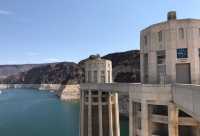
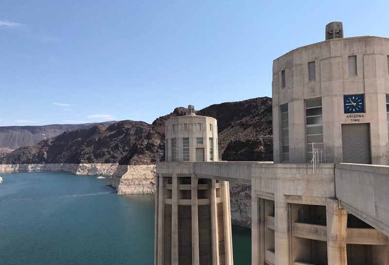
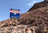
The Hoover Dam Bridge is the boundary between Nevada and Arizona, and also the bridge across two time zones. Walking on Hoover Dam, the Pacific time zone is on one side and the Mountain time zone is on the other.
;
Hoover Dam Review
4.5 /5271 Reviews


1 / 6


5/5
Hoover Dam
Posted: Sep 10, 2017


2 person liked this
Like
 5/5Outstanding
離開拉斯維加斯後來到1931年興建的胡佛水壩,位於美國亞利桑那州與內華達州交界處的全美國🇺🇸最大水壩,同時也是電影變形金拍攝場景。來到胡佛水壩最有趣的,就是因為水壩本身連接了亞利桑那州、內華達州,兩州存在著一小時的時差,因此短短幾步之間的兩座塔柱上,分別顯示了兩州不同的這時間,多走一步你就多了一個小時呢!
Posted: Jan 23, 20240 5/5Outstanding
During a trip to Las Vegas, we took a day and drove out to Hoover Dam. We signed up for a tour, which included a mini documentary and a guided trip down to see the inner workings of the dam. Very educational - we saw one of the greatest American engineering marvels from the Great Depression era, all designed from pen and pencil and built by man. The dam was constructed under budget and ahead of schedule too!#hooverdam #american #engineeringmarvel
Posted: May 14, 20231 4/5ExcellentOriginal Text
The Hoover Dam is a famous water project on the Colorado River. It is on the border of Nevada and Arizona. The dam is 221m high and the top of the dam is 379m long. It is surrounded by mountains and has a steep terrain and beautiful scenery.
Posted: Apr 8, 20230 5/5OutstandingOriginal Text
The Hoover Dam is a key project on the Colorado River in the United States, which can prevent floods, irrigation, power generation, shipping, water supply and so on. The dam is a concrete gravity arch dam with a high dam height. Construction began in April 1931 and was completed in March 1936. It occupies an important position in the world's water conservancy engineering.
Posted: Apr 24, 202274 5/5Outstanding
Amazing engineering. Nice view from top of the dam and over the bridge (Nevada to Arizona). Roads were amazing. Feel like we’re just floating. Well maintained. Took four years to finish the construction of the dam. Would recommend this place.
Posted: Oct 2, 20230 5/5OutstandingOriginal Text
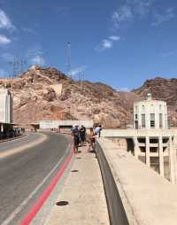
When we arrived at Hoover Dam, we parked our car in the parking lot of the tourist center ($10/unlimited time), took enough drinking water and walked to the top of the dam (the temperature was as high as 40 degrees Celsius on that day, it was very important to replenish water). The radial gate was quite powerful to watch from high to low. Not far away, Highway 93 crossed the mountain, and its bridge became the perfect background of the dam. Large diversion tunnels and large power grid towers form a magnificent picture. The top of the dam is a two-lane road. We are happy to walk right and left. We have a panoramic view of Lake Mide and the dam. Then we take the elevator down to the viewing platform. After security check, we know that it is a toll-paying attraction. In fact, it is the difference between far and near. USD10 yuan/person feels worthless and goes back to the top of the dam.
Posted: Oct 3, 201614 5/5OutstandingOriginal Text
We stopped here on our way back to Las Vegas from the Grand Canyon West Canyon. Crossing the Colorado River, Hoover Dam is the largest dam in the United States, also known as the "Desert Drill". To watch the Hoover Dam carefully, you need to walk on the high Mike O" Callaghan-Pat Tillman Memorial Bridge (260 meters from the water surface). The bridge is an arch bridge across the Colorado River connecting Arizona and Nevada. The McO'Callahan-Patterterman Memorial Bridge is named after Nevada Governor McO'Callahan and local American football player Patterterman. The latter joined the Army from the Arizona Cardinals and died in Afghanistan. The Memorial Bridge is tall and steep. The wind is very strong that day. Standing on the bridge, it feels like being blown away by the wind.
Posted: Aug 9, 201617- 1
- 2
- 3
- 4
- 54
Popular Destinations
London Travel | Manchester Travel | Bangkok Travel | Istanbul Travel | Shanghai Travel | Hong Kong Travel | Barcelona Travel | Birmingham Travel | Paris Travel | Kuala Lumpur Travel | Tenerife Island Travel | Guangzhou Travel | Amsterdam Travel | Edinburgh Travel | Manila Travel | Busan Travel | Hakone Travel | Southport Travel | Hefei Travel | Brighton and Hove Travel | Pennsylvania Travel | Nakhon Chai Si District Travel | Houston County Travel | Olcott Travel | Wolverton and Greenleys Travel | Mississauga Travel | Beizhen Travel | Troy Travel | Clarkdale Travel | Griffith City Council Travel
Recommended Attractions at Popular Destinations
Bangkok attraction near me | Tokyo attraction near me | Manila attraction near me | Hong Kong attraction near me | Seoul attraction near me | Taipei attraction near me | Los Angeles attraction near me | New York attraction near me | Shanghai attraction near me | Kuala Lumpur attraction near me | Shenzhen attraction near me | Guangzhou attraction near me | Osaka attraction near me | Singapore attraction near me | London attraction near me | San Francisco attraction near me | Beijing attraction near me | Macau attraction near me | Bali attraction near me | Paris attraction near me | Orlando attraction near me | Jakarta attraction near me | Ho Chi Minh City attraction near me | Phuket attraction near me | Chicago attraction near me | Toronto attraction near me | Cebu attraction near me | Dallas attraction near me | Istanbul attraction near me | Dubai attraction near me
Popular Attractions
Gardens by the Bay | Colosseum | Hampton Court Palace | Tiger Kingdom - Phuket | Birmingham New Street | Yorkshire Lavender | Columbia Pictures Aquaverse | Warner Bros. Studio Tour Tokyo - The Making of Harry Potter | Yu Garden | Universal Studios Hollywood | Rockefeller Center | Qingcheng Mountain | Tokyo DisneySea | "The Song of Everlasting Sorrow" | Tangshan No.1 Hot Spring Resort | City of Arts and Sciences | Museum of Islamic Art | Shiv Temple | Islam Huddeen Mosque | Musolla Muhajirin Muhammad | 白沙屯東龍宮 | Chausala Shiv Mandir | South Windsor Parks & Recreation | Casa Del Rey Int. | St Thomas' Church | Radha Bollov Jiu Temple | Singapore Flyer | Walt Disney World Resort | Vana Nava Water Jungle | Escape Penang
Popular Travelogues
Bangkok Travelogue | Tokyo Travelogue | Hong Kong Travelogue | Seoul Travelogue | Los Angeles Travelogue | New York Travelogue | Shanghai Travelogue | Kuala Lumpur Travelogue | Shenzhen Travelogue | Guangzhou Travelogue | Osaka Travelogue | Singapore Travelogue | London Travelogue | San Francisco Travelogue | Beijing Travelogue | Macau Travelogue | Bali Travelogue | Paris Travelogue | Ho Chi Minh City Travelogue | Phuket Travelogue | Chicago Travelogue | Toronto Travelogue | Dubai Travelogue
Payment Methods
Our Partners
Copyright © 2024 Trip.com Travel Singapore Pte. Ltd. All rights reserved
Site Operator: Trip.com Travel Singapore Pte. Ltd.
Site Operator: Trip.com Travel Singapore Pte. Ltd.