


1 / 4


Mentioned in This Moment
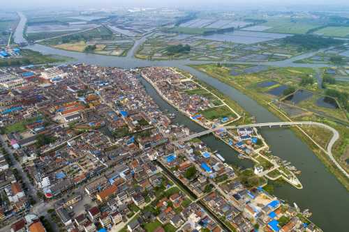
4.7/513 reviews | Natural scenery
Baoying
View
Show More
Popular Destinations
Tehran Travel | Oslo Travel | Stockholm Travel | Bengaluru Travel | Colombo Travel | United Kingdom Travel | Harare Travel | Moscow Travel | Birmingham Travel | Taipei Travel | Genting Highlands Travel | Krakow Travel | Hamburg Travel | Galway Travel | Baku Travel | Okehampton Travel | Myanmar Travel | Kaipara District Travel | North Berwick Travel | Kunene Travel | Scharbeutz Travel | Cape Elizabeth Travel | Phang Nga Province Travel | Elkhart County Travel | Lika-Senj County Travel | Nemaha County Travel | Sakurai Travel
Recommended Attractions at Popular Destinations
Bangkok attraction near me | Manila attraction near me | Tokyo attraction near me | Taipei attraction near me | Hong Kong attraction near me | Seoul attraction near me | Kuala Lumpur attraction near me | Los Angeles attraction near me | Shanghai attraction near me | New York attraction near me | Shenzhen attraction near me | Osaka attraction near me | Singapore attraction near me | London attraction near me | Guangzhou attraction near me | San Francisco attraction near me | Beijing attraction near me | Macau attraction near me | Bali attraction near me | Jakarta attraction near me | Paris attraction near me | Ho Chi Minh City attraction near me | Istanbul attraction near me | Phuket attraction near me | Chicago attraction near me | Seattle attraction near me | Toronto attraction near me | Orlando attraction near me | Cebu attraction near me | Chiang Mai attraction near me
Popular Attractions
Water World Ocean Park Hong Kong | Nigloland, Parc D'Attractions & Hotel | Colosseum | Ba Na Hills | The Roman Baths | Blenheim Palace | Eiffel Tower | Splashdown Quaywest | King Power Mahanakhon Sky Walk | The Centre Pompidou | Trevi Fountain | Yingxi Fenglin Corridor | The Shore Sky Tower | Farm In The City | Feilong Mountain Park | Church of the Life-Giving Trinity | Transfagarasan | Przekrój geologiczny przez Sudety Zachodnie | Santuario De Schoenstatt | Assembléia de Deus Congregação Monte Do Senhor | Ancient Israel Music - Voices of Eden | Twin Ridge II Park | Museo degli Sguardi | Erdbeermund Singen | SplashMania WaterPark | VinWonders Phu Quoc | Shanghai Tower | Sanxingdui Museum | Museum Island | Tiger PARK Phuket
Popular Restaurants in Baoying
胡家长鱼面(东园路店) | 烟火鱼乡(宝应店) | Sanbinglu Fish | 明洞王妃家烤肉(宝应店) | 晨怡大酒店(鱼市口店) | 本清素我家酸菜鱼(宝应店) | CoCo都可(宝应时代店) | 港澳饼家(世纪园八分店) | 港澳饼家(大上海店) | 油尖旺主题餐厅 | 图们烧烤(宝应店) | 村夫烤鱼蒙古巴图鲁烤羊腿(白田中路店) | 缤果鲜茶(园丁路店) | 小城故事 | 紫燕百味鸡(扬州泰山路店) | 香飘飘海鲜烧烤(世纪园店) | 重庆四姐老火锅(盛世家园店) | ZHEN NAI HUI SUO XIN SU GUO DIAN | 梧桐·印象餐厅(宝应一店) | 港澳饼家(安宜路七分店) | 港澳饼家(鑫宝佳园店) | 意浓咖啡厅(白田中路店) | 华莱士·全鸡汉堡(扬州白田中路店) | 中电美食 | 7分甜(扬州宝应时代国际店) | 尚膳私厨(邻里中心店) | 陈大家常菜馆(宁国寺店) | 1916 | 围炉小巷(宝应店) | Huangguan Restaurant
Popular Ranked Lists
Popular Best Things to Do in Solukhumbu | Top 12 Local Restaurants in Lanzhou | Top 15 Local Restaurants in Narita | Popular Best Things to Do in Goyang-si | Top 12 Local Restaurants in Glasgow | Popular Luxury Hotels Near Bijaipur | Popular Best Things to Do in Nisava District | Popular Best Things to Do in Venice | Top 10 Local Restaurants in Mexico City | Popular Luxury Hotels Near Negros | Popular Premium Hotels Near Cotentin Peninsula | Top 10 Local Restaurants in Johor Bahru | Popular Best Things to Do in Nagano | Top 19 Local Restaurants in Luoyang | Top 20 Local Restaurants in Lhasa | Top 9 Local Restaurants in Mandalay | Popular Best Things to Do in Lavreotiki | Popular Luxury Hotels Near Salzkammergut | Popular Best Things to Do in Sagarmatha | Popular Best Things to Do in Udon Thani | Popular Premium Hotels Near Skardu | Popular Best Things to Do in Wiang Pa Pao | Popular Local Restaurants in Bangkok | Popular Best Things to Do in Nagakute | Top 10 Local Restaurants in Casablanca | Popular Luxury Hotels Near Black Isle | Top 10 Local Restaurants in Cairns | Top 15 Local Restaurants in Christchurch | Popular Luxury Hotels in Kranj | Top 20 Local Restaurants in Xining
Payment Methods
Our Partners
Copyright © 2025 Trip.com Travel Singapore Pte. Ltd. All rights reserved
Site Operator: Trip.com Travel Singapore Pte. Ltd.
Site Operator: Trip.com Travel Singapore Pte. Ltd.