OverviewBookNearbyReviewsWin PrizesDetailsRecommended
Share to
Ashgang Colorful Peaks Scenic Area in Guide National Geological Park
貴德國家地質公園阿什貢七彩峯叢景區5.9
737 Reviews
Closed Today Open tomorrow at 08:40-17:00
Recommended sightseeing time:2-3 hours
Address:
Ashang Village, Huangrang Township, Guide County, Hainan Tibetan Autonomous PrefectureMap
Phone0974-8569920
What travelers say:
The gem of nature, Colorado, China, very special terrain and landforms, a different experience, Guide is a treasure, and two places near Xining are the ghosts of nature.
More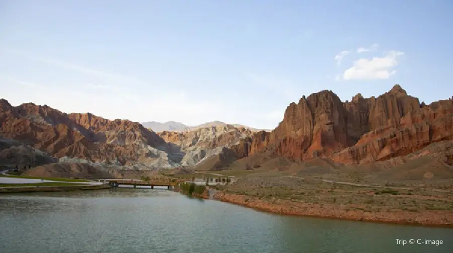
See all 24 photos
Saved by 26
Ashgang Colorful Peaks Scenic Area in Guide National Geological Park Highlights: Must-See Features and Attractions
Some information may have been translated by Google Translate
Ashgang Colorful Peaks Scenic Area in Guide National Geological Park, comprising 13 cultural theme squares and seven Danxia canyons, is an ideal destination for tourism and sightseeing, dining and entertainment, as well as relaxing and releasing the mood. A variety of geological relics reflect the evolution of the Qinghai-Tibet Plateau during the geological history, and also record the development history of the Yellow River and the changes of the natural environment of Guide. This place is available for sightseeing, leisure and vacation, as well as science popularization education and scientific research.
Recommendations Near Ashgang Colorful Peaks Scenic Area in Guide National Geological Park
Ashgang Colorful Peaks Scenic Area in Guide National Geological Park Reviews: Insider Insights and Visitor Experiences
Some reviews may have been translated by Google TranslateWrite a Review
/5
Outstanding ReviewsAll (737)
Latest
With Photos (310)
Verified Booking (458)
Positive Reviews (605)
Negative Reviews (19)
- 1
- 2
- 3
- 4
- 100
Additional Information
Available Amenities
Shuttle bus
View More
You Might Also Like
Longwu Temple
4.4
4.6/555 Reviews
From US$8.30
Fattai Mountain Scenic Area
3.1
4/555 Reviews
From US$2.77
Chinese Fuyunlun
3.9
4.4/552 Reviews
Yellow River Girl Lavender Garden
2.3
5/54 Reviews
Nearby Attractions
Qinghai Guide Huangheqing National Wetland Park | Chinese Fuyunlun | 清清黃河景區 | Qingqinghuanghe Waterwheel Plaza | Guide Ancient City | Guide Confucious' Temple and Yuhuang Pavilion | Guide Huanghe Bridge | Qinghai Guide Wenquan Yuliao Villa | Qianzi Lake Huangheqing Wetland Park) | Yellow River Qishiyuan | Yellow River Girl Lavender Garden | 青海明長城(貴德段) | 貴德倚河園 | Lijiaxia Reservoir | Nanhai Palace | Huanghe Drift Square | Plateau Healthy and Leisure Resort | 河西文昌廟 | Qiongmao Temple | Garang Mosque | Mie Na Temple | 青海貴德黃河清國家濕地公園-觀景台 | Guide Hot Spring Natatorium | Hexizhen Mosque | 青海貴德國家地質公園博物館 | Huanghe Nation Culture Park | Guide Library | Yizhashi Village | Shangwanquhu Village | Huquwanxia Village
Popular Types of Attractions in Guide
Nature | Mountains | Grasslands | Forests | Religious Sites | Temples | Churches and Cathedrals | Mosques | Exhibition Centers | Museums | Fine Art Galleries | Exhibition Halls | Architecture & Landmarks | Squares | Featured Neighborhoods | Historical Architectures | Lifestyle | Resorts | Libraries | Private Theaters | Parks | City Parks | Botanical Gardens | Theme Parks | Historic Sites | Historical Sites | Cemeteries | Ancient Towns | Traditional/Cultural Experiences | Villages
Popular Restaurants in Guide
LI XIANG LOU FAN DIAN | 梨花村农家乐 | 金水源生态餐饮 | 老陕面馆(黄河人家店) | 小白农庄 | 小四川(迎宾西路店) | 24k国际饭店餐饮部·清真 | 贵德银龙国际饭店·餐厅 | 谭鸭血老火锅(贵德梨都广场店) | 雅苑私房菜 | 南苑 | HUANG MEN JI MI FAN | XIANG DE TIAN XIA | PAN ZI KAO YANG ROU | 尕让穆沙羊肉面片馆 | 金元烤肉美食城 | 清源农庄 | 川香阁(同德家园店) | ZHEN HUA LA MIAN DA WANG | 阿迪茶堡 | 安泊儿牛肉面 | 梨都园 | 小白农庄 | DE SHENG MEN HUO GUO | 星月美食城(迎宾西路店) | 马金龙麻辣烫(青海贵德店) | 伊兴园农庄 | 大团结柴火鸡(贵德总店) | DING DING XIANG CAI GUAN | LAO ZI HAO SHOU ZHUA MIAN SHI GUAN
Popular Destinations
Krabi Travel | Kuwait Travel | Los Angeles Travel | Dublin Travel | Nottingham Travel | Aberdeen Travel | Malaysia Travel | Brisbane Travel | Cairo Travel | Cape Town Travel | Agadir Travel | Ankara Travel | Maldives Travel | Hobart Travel | Calgary Travel | Wellingborough Travel | Lijiang Travel | Pontevedra Travel | Klamath County Travel | Kronshtadt Travel | Mae Fa Luang Travel | Volterra Travel | San Miguel County Travel | xiandu Travel | North Dundas Travel | Clutha District Travel | Cheektowaga Travel | Shiso Travel
Recommended Attractions at Popular Destinations
Bangkok attraction near me | Tokyo attraction near me | Manila attraction near me | Hong Kong attraction near me | Seoul attraction near me | Taipei attraction near me | Los Angeles attraction near me | New York attraction near me | Shanghai attraction near me | Kuala Lumpur attraction near me | Shenzhen attraction near me | Osaka attraction near me | Singapore attraction near me | London attraction near me | Guangzhou attraction near me | San Francisco attraction near me | Beijing attraction near me | Macau attraction near me | Bali attraction near me | Paris attraction near me | Orlando attraction near me | Jakarta attraction near me | Ho Chi Minh City attraction near me | Chicago attraction near me | Phuket attraction near me | Toronto attraction near me | Dallas attraction near me | Istanbul attraction near me | Cebu attraction near me | Seattle attraction near me
Popular Trip Moments
Guide to the Ashikong Qicai Peaks - A breathtaking Danxia landform | Guide County Lotus Guangming Palace | Guide (Ashgong) National Geological Park | Laji Pass and the breath-taking view! | The pass of Laji Mountain at 4188 meters | Guide National Geological Park, unexpectedly beautiful! | Laji Mountain | The mountain does not see me, I go to see the mountain | Little Hot Pot Oasis in Guide
Popular Travel Types
More Things To Do in Guide
4-Day Private Tour in Qinghai: Ashgang Colorful Peaks, Laji Mountain, Chaka Salt Lake, Emerald Lake, The Water Yadan Geopark, West Tignar Lake, 315 Highway | 3-Day Xining Private Tour: Qinghai Lake, Erlangjian Scenic Area, Chaka Salt Lake, Dadongshu Mountain Bealock, Zhuoer Mountains, A'Rou Grand Temple, Menyuan Rapeseed Flower Field | 2-Day Xining Private Tour: Tar Termple, Laji Mountains, Chaka Salt Lake, Qinghai Lake, Jinyintan Grassland | 2-Day Xining Private Tour: Tar Temple, Laji Mountain, Riyue Mountains, Daotang River, Qingha Lake, Chaka Salt Lake | 3-Day Xining Private Tour: Tar Temple, Laji Mountain, Qingha Lake, Chaka Salt Lake, Dadongshu Mountain Bealock, Zhuoer Mountains, Mole Grassland, A'Rou Grand Temple | 3-Day Xining Private Tour: Tar Temple, Laji Mountain, Riyue Mountains, Daotang River, Qinghai Lake, Heimahe, Dadongshu Mountain Bealock, Zhuoer Mountain, A'Rou Grand Temple | Laji Mountain + Guide National Geopark Ashgong Colorful Peaks attraction+ Qingqing Yellow River attraction+ China Fortune Cruise One-Day Tour [Exclusive Chartered Chartered Vehicle Travel + Free Children's car seats] | China eSIM Day Pass/data Package days selected without cards QR code | China·Hong Kong·Macau eSIM|Unlimited 4G High Speed Data | China Mainland eSIM|China Mobile Unlimited 4G High Speed Data | China, Hong Kong, and Macau eSIM|Total 5GB/10GB/15GB/20GB High-speed 4G LTE Unlimited high-speed data | Mainland China eSIM |China Mobile 4G high-speed unlimited data eSIM | Asia・Australia eSIM|AIS SIM2Fly 8 days 6GB High-speed Unlimited 5G/4G Data | [China Mainland] eSIM | SIM to China | 8GB 8days 4G high speed | Mainland China + Hong Kong + Macau eSIM 4G Data Daily Plan QR Code | AIS Asia esim data package (QR code) | 6-Day Private Silk Road Tour of Xining, Zhangye, Jiayuguan and Dunhuang Highlights | Global multi-region A series eSIM|High-speed data, travel and business Internet access, optional unlimited data, optional days, QR code | Private Full-day Xining City Tour with Lunch | Global (30 Countries) eSIM Data Package (QR Code) | One-day tour to Kanbula National Forest Park [Overlooking the blue water Danxia: 4/6 people place an order to form an independent group + stop and take photos at will + pure play without shopping] | Sun Moon Mountain + Daotang River + Chaka Salt Lake + Qinghai Lake One-Day Tour [Two Lakes Quick Tour 1 Day] | Xining City Private Full Day Tour | Global multi-region B series eSIM|Universal in 54 countries Travel and business Internet access Optional unlimited data Optional days QR code | [FLASH SALE] China, Hong Kong, Macau eSIM - Data plan by Gohub (QR Code) | Sun Moon Mountain + Qinghai Lake One-Day Tour [Exclusive Chartered Vehicle Free Travel + Check-in Niche Unique Beauty + Pure Play without Shopping] | [Tested in Mainland China] esim|100MB/1GB/10GB Traffic packages | 6-Day Private Silk Road Tour of Xining, Zhangye, Jiayuguan and Dunhuang Highlights | Global multi-region C series eSIM|Common in 84 countries Travel and business Internet access Optional unlimited data Optional days QR code | <Private charter> Day trip to Tibetan Buddhist temple [Taal Monastery] and China's largest salt lake [Qinghai Lake] Lunch included <Hotel pick-up/Japanese guide/1 person departure/Depart from Xining>
Payment Methods
Our Partners
Copyright © 2024 Trip.com Travel Singapore Pte. Ltd. All rights reserved
Site Operator: Trip.com Travel Singapore Pte. Ltd.
Site Operator: Trip.com Travel Singapore Pte. Ltd.
The gem of nature, Colorado, China, very special terrain and landforms, a different experience, Guide is a treasure, and two places near Xining are the ghosts of nature.
Very close to Guide from Xining, it is recommended to go and see! It's really beautiful! The park is not very big, free for over 60 years old! Tickets 30 yuan! Small train 🚄 30 yuan! From the beginning of the door, there is a service staff to lead, first watch the promotional film, then explain, then do the car, the driver drives all the way to explain, very good experience! It takes only 2 kilometers to walk, and there is no problem with the elderly. Because of the crustal movement, the previous sea has become a mountain. Due to different geology, different wetness and different colors, there are five colors of soil in the park, and the mountain presents a few different colors of landscape! so beautiful! Very spectacular, very beautiful, similar to Zhangye Danxia landform landscape!
Guide National Geopark is also called Ashgong, located in Ashgong Village, Yanran Township, Guide County, Hainan Prefecture, Qinghai. From Guide County, cross the Guide Yellow River Bridge, along National Highway 227, cross the Yellow River Wetland Park, and see a Danxia Peak group. In front of the ticket office of the scenic spot is a large square and parking lot, the north is the entrance of the scenic spot, and the south is the exit. The scenic spot is composed of 13 cultural theme squares and seven Danxia Canyon. The interior area covers 3,000 mu and the exterior area covers 50,000 mu. Danxia landform is developed from red sandstone, Ashgon Danxia landform, formed 120 million years ago. The red sandstone layer is cut under the Yellow River and the Himalayas are uplifted, so that the red sandstone hidden deep in the formation is exposed, and after thousands of years of erosion and strong wind sculpture, it has formed a thousand-shaped rock cliff. Enter the scenic spot, on the cement-built square, the style of Danxia around you is different, the sun is strong, and the white clouds are rising. In the center of the square, there are stone carvings in the shape of Guide County, and the blue Yellow River runs through them. The stone carvings say "Qinghai Guide National Geopark". There is a geological museum on the east side of the square, which is displayed in pictures and images. The narrator spoke very quickly, and the introduction ended after a while. I felt that the significance of the visit was not great. The museum came out and walked north along the square to the mountain gate. There are two top columns in the mountain gate, and the book "the earth veins are stretching on the ground, and the people are the source of the ancient love." The link is not neat, but it is more suitable for the scene. Crossing the pedestrian bridge, facing a small door, the book "Colorful Peak Cong, the earth behind the wall". Enter this door
Unexpected scenery, originally planned to go to Zhangye, but the reason for the distance temporarily changed to here, the geological park does not lose Zhangye, very pleasant experience. There is also a free explanation, the arrangement is very good.
20220711下午:1、阿什贡七彩峰丛是距贵德县20公里处的丹霞地貌山峦,山岩色彩艳丽、沟壑崎岖,位于辽阔壮美的贵德国家地质公园内,是地质公园内的主要景区,始建于1998年,占地158平方公里,分贵德国家地质博物馆、千佛峡、女娲侠、女娲湖、轩辕峡、擎天侠、问天峡、通天峡、后土峡、天地人缘博物馆9部分,每个区域分配有讲解员驻点讲解,结构简单,全程单向无回头路,都是自然景观、无人文景观。①地址:青海海南藏族自治州贵德县尕让乡阿什贡村②交通:不通公交,开车很好停③旺季:无④用时:3小时⑤票价:95元2、贵德国家地质博物馆位于山门处,馆内面积不大,用模型、图文的形式介绍了贵德地质公园的地质、动植物概况。3、通过迎客牌坊后到达摆渡车站,摆渡车直接到达第一站女娲峡,从女娲峡步行单向通行到出口,全长1公里,沿途会途经:①千佛峡(创世峡):占地2平方公里,摆渡车会途经,但不能下车。②女娲峡:因峡谷半高处呈人形,形似女娲造人时的半成品而得名。沿小段山路绕一圈,山上风大但视野宽广,能俯瞰全山脉的美景,红、蓝、灰、绿、黄等颜色相间交织,如一条彩虹山脉延伸到尽头的蓝天白云中。下山路会返回到观光车下车站,车站处色彩缤纷的花丛颜值很高,花束密集颜值高,山野间也有不少中原地区少见的野花品种。女娲峡有另一条通向峡谷深处的山道,可穿越峡谷里直接到最后一峡,全长2公里,适合徒步探险党。③女娲湖:湖边荡漾的芦苇像幕布一样让小湖全景若隐若现,形成天然的拍照框。小湖与四周沟壑纵横、荒凉沧桑的地貌形成极大反差,别具一格地成为必拍照点,角度得当可以拍出对面山峦的倒影。④轩辕峡:以下几峡外貌跟女娲峡都差不多,只能沿山下主道观赏,无登山道,主道旁无围栏,徒步爱好者可以自己到峡谷下与大自然亲密接触。⑤擎天峡。⑥问天峡。⑦通天峡(探险峡)。⑧后土峡。⑨七彩广场:空地广场,周围没有过多装饰,除了山丘沟壑便是野草野花。⑩天地人缘博物馆:馆内用图文、模型、实物、讲解员讲解等形式介绍了此七彩丹霞被赋予的以“缘”为纽带将“天、地、人”结合为一体的人文内涵,景区的开发商名为青海天地人缘文化旅游发展有限公司,有讲解员全程跟随讲解每一环节,全程不长,约10分钟。3、贵德国家地质公园共占地554平方公里,共分3大板块,即阿什贡七彩峰丛园区、麻吾峡风蚀龛地貌园区……字数超限,在最后一张图片里继续
空气好风景美