https://uk.trip.com/moments/poi-yunmeng-mountain-scenic-area-64263803
3.8
4.4/5
431 reviews
Natural scenery
Mountain climbing
Beijing Yunmeng Mountain Scenic Area is located in Miyun District, Beijing, about 80 kilometers away from Beijing city. It is a famous scenic spot, national forest park and national geological park in Beijing. It was rated as a scenic spot in Beijing in 2000, and was rated as a national forest park and national geological park in 2009. Yunmeng Mountain combines the majesty of Mount Tai, the danger of Mount Hua, the strangeness of Mount Huang and the beauty of Mount Emei, and is known as the Little Huangshan in the North. It is a famous mountain with peaks, rocks, pools, waterfalls, clouds and pines, and is known for its majesty, danger, strangeness, beauty, seclusion and vastness. The natural scenery is very beautiful. "The blue sky and the green mountains, the bright golden peaks" The hundreds of miles of the Northern Qi Great Wall, the Ming Great Wall and the Miyun Reservoir complement each other. It is a rare place in Beijing where you can see the mountains, waters, the Great Wall, clouds, waterfalls and stone pines.
Show More
Yunmeng Mountain Scenic Area Address:
Yunmeng Mountain Scenic Area, Shicheng Village, Shicheng Town, Miyun District, Beijing
Yunmeng Mountain Scenic Area Recommended sightseeing time:
0.5-1 day
Yunmeng Mountain Scenic Area Phone:
010-61016289
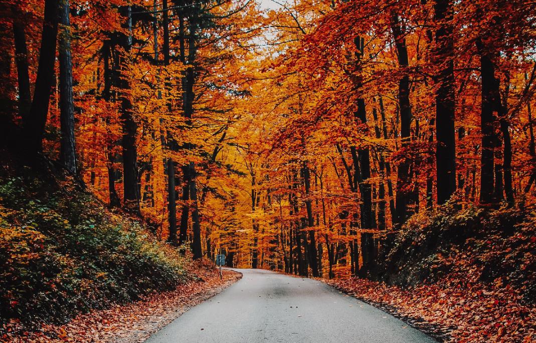
Enjoying autumn in Yunmeng Mountain, the fairy tale of autumn in my heart
The autumn scenery is splendid, and Yunmeng Mountain at this time is at its peak of beauty, 🍂 the continuous mountains are intertwined with colorful forests everywhere, like a fairy tale of autumn, satisfying all your fantasies about autumn, it's incredibly beautiful!
~
💼Travel preparation:
1⃣Comfortable shoes👟, because you will walk a lot of mountain roads.
2⃣Bring water and snacks🍓, the food on the mountain may be more expensive.
3⃣Remember to bring a camera📷, to record the beautiful scenery.
4⃣Wear a bright dress👗, it can contrast with the autumn scenery
~
In Yunmeng Mountain, you can enjoy the colorful autumn, and there are many ways to visit Yunmeng Mountain, including hiking, 🚡 taking a sightseeing car and cable car, etc.
🔥Play and check in
✅Hiking on the Orange Road of Yunmeng Mountain
On the 7 km Orange Road, you can stroll from Wanglong Slope to Jingshan Pavilion, and then to the Great Wall Viewing Platform. The mountains and red leaves reflect each other, and the green mountains are dressed in a touch of red. You can enjoy the beautiful autumn scenery all the way. But it really consumes a lot of energy, everyone should prepare some water and food when hiking!
✅Qingkongling Viewing Platform
Standing on the top of Qingkongling, the autumn red leaf scenery of Yunmeng Mountain has reached its peak, a very colorful picture! In the sea of clouds, frost dyed red maple, full of autumn, it's really good to shoot📸!
✅Or walk and stop to explore the mountain trail on foot, admiring this landscape, all in front of you are gradually unfolding gorgeous oil paintings, very beautiful, everyone must not miss it here when enjoying the autumn.
✅In the 520 restaurant in the scenic area, you can taste the delicate and delicious reservoir fish. If you have plenty of time, you can also stay in the mountain hotel in the mountains, which is also a very good choice!
~
Autumn is strong, all mountains are autumn colors, you must come to Beijing Yunmeng Mountain Scenic Area once!
ExploringEssence
58
Life advice: You always have to visit Beijing North, where the Great Wall will leave you in awe.
2. **Yunmengshan Mountain (Miyun)**
*"Beijing's Mini Huangshan, a poetic landscape"*
Marvel at the breathtaking views of peculiar peaks, cascading waterfalls, the ancient Great Wall, and the Miyun Reservoir. Stroll through the "520 Love Valley," take a cable car ride through the clouds and mist, and make a promise at 1314 meters above sea level, letting the mountains and rivers witness your romance.
3. **Shenglian Mountain (Fangshan)**
*"Western Beijing's Mini Five Sacred Mountains, where Buddhism and Taoism coexist"*
Admire the lotus-shaped peaks formed by karst landforms, with a 57-meter-tall statue of Lao Tzu standing atop the mountain. Wander along "Tianjie," watch the clouds and mist swirling around ancient temples, listen to the streams flowing through the valleys, and find a place for spiritual retreat.
4. **Fragrant Hills (Haidian)**
*"Crimson leaves covering the hills, remnants of a royal garden"*
In autumn, fiery red leaves blanket Incense Burner Peak; in spring, apricot blossoms resemble snow; and in summer, lush greenery provides ample shade. Ascend to a high vantage point and take in the panoramic view of Beijing, where the ancient charm of Jingyi Garden blends seamlessly with modern prosperity.
5. **Thousand Spirits Mountain (Fengtai)**
*"From barren hills to a Buddhist sanctuary, a rebirth"*
Once a limestone quarry, now 95% covered in greenery. Take the 1869-meter cable car ride for a bird's-eye view of the mountains, explore 18 Buddhist grottoes, and feel the harmony of nature and faith under the smiling gaze of the Maitreya Buddha.
---
### **Great Wall Copy**
1. **Badaling Great Wall (Yanqing)**
*"He who has never been to the Great Wall is not a true man, atop the giant dragon overlooking mountains and rivers"*
The essence of the Ming Great Wall, with 4770 meters of wall winding like a dragon. In autumn, the Red Leaf Ridge is ablaze with color, while at night, the Great Wall lights up like a galaxy. The thousand-year-old beacon towers still tell the legend of "The Jade Gate Fortress."
2. **Juyongguan Pass (Changping)**
*"The first and most important pass under heaven, one man can hold it against ten thousand"*
Guarding the throat of the Guangou Valley, the Cloud Platform's archway is inscribed with six languages, bearing witness to the ethnic integration of the Yuan Dynasty. In spring, trains pass through a sea of flowers, while in autumn, the wall contrasts with the colorful forests, creating a moving epic.
3. **Mutianyu Great Wall (Huairou)**
*"The Great Wall is magnificent, but Mutianyu stands out"*
Double-sided battlements outline the horizon, with three enemy towers standing together like "Zhengguantai." Cherry blossoms in spring, maple leaves in autumn, lush greenery in summer, and snow in winter—every season is perfect for hiking and experiencing the magnificence of the "Great Wall leaping like a dragon among the mountains."
4. **Simatai Great Wall (Miyun)**
*"The most magnificent section of the Great Wall, perilous and unique"*
Built along the cliffs of the Yanshan Mountains, the enemy towers are a "Great Wall Museum." During a night tour, the lights of Gubei Water Town intertwine with the wall under the starry sky, as if traveling through a thousand years of beacon smoke.
5. **Jiankou Great Wall (Huairou)**
*"The soul of the Wild Great Wall, primitive and desolate"*
Naturally perilous and unrestored, the autumn foliage contrasts with the remnants of the wall, making it a photographer's paradise. Every step is a mark of history, every glance a vista of magnificent mountains and rivers.
---
### **Copy Blending Mountains and the Great Wall**
*"Beijing's mountains and rivers are the winding spine of the Great Wall; the stories of the Great Wall are the silent watch of the mountains. Ascend to a high vantage point, watch the giant dragon coiled around the Yanshan Mountains, and listen to the pines whisper tales of a thousand years. Here lies both nature's gift and civilization's totem."*
For more detailed history or travel guides, please refer to the relevant attraction introductions.
Noah~Ward86
Weekend camping and hiking in the suburbs of Beijing | Wuling Mountain and Yunmeng Mountain
🌿Healing trip to the suburbs of Beijing|Wuling Mountain + Yunmeng Mountain|24-hour romantic escape into fairyland
✨【Dream Destination】
Yunmeng Mountain (Miyun | 1.5 hours drive from Beijing | Cloud Garden of "Little Huangshan Mountain in the North")
Wuling Mountain (Hebei | 2.5 hours drive from Beijing | The most beautiful starry sky observation site in North China)
🚗【Self-driving tips】
The Yunmeng Mountain winding road is like silk, and you can feel the mountain breeze when you open the window
Some sections of the road in Wuling Mountain are shrouded in mist, so experienced drivers are recommended to drive (but it really feels like entering a Hayao Miyazaki animation!)
🌸【Four Seasons Love Letter】
🌥️Yunmeng Mountain (Ticket price: 78 yuan | Cable car one-way: 98 yuan)
▫️April-June: The azalea sea on the top of the mountain is breathtakingly beautiful. Wearing a white dress and turning around in the flowers is a blockbuster
▫️July-August: 25℃ natural air conditioning, the light spots on the mossy stone steps sparkle like broken diamonds
▫️September-October: When the forest is full of colors, stand on the 520 Observation Deck and lock a love lock with your loved one🔒
✨Secret experience: The "Buddha's Light" spectacle in the evening (need luck!), the sea of clouds latte at the mountaintop cafe
🌌Wuling Mountain (Ticket price: 108 yuan | You can drive up the mountain by yourself)
▫️June-August: The Milky Way at 3 a.m. looks like an overturned diamond box. Remember to bring a blanket and lie on the observatory.
▫️September-October: Sunrise over the sea of clouds like an ink painting, the reeds on the Immortal Peak glow in the backlight
▫️November-March: The rime is crystal clear, like entering the fairy tale world of "Frozen"
✨Romantic details: forest cabins halfway up the mountain (booking is required six months in advance!), picnic spots by the stream
📸【Photography Guide】
▪️Yunmengshan: Wear light colors! Take pictures of the reflections in the mirror lake of Heilongtan
▪️Wuling Mountain: Bring fill light! For starry sky portraits, it is recommended to wear bright-colored sweaters
💝【Exclusive Tips】
✅ It is recommended to buy cable car tickets at Yunmeng Mountain to save your energy for the fairyland walk on the top of the mountain
✅ Bring a hot pack when stargazing in the early morning at Wuling Mountain! The temperature on the top of the mountain was 10℃ lower than forecast
🎀Hidden Easter eggs: The farmhouse at the south gate of Wuling Mountain has delicious firewood stewed fish, and the shredded radish pancakes at the late night canteen in Gubei Water Town will make you want to cry... Wuling Mountain Yunmeng Mountain Scenic Area
Serendipitousadventure
Beijing Azalea Blossom Viewing: A Complete Guide to Spring's Limited-Time Romance
"While the Forbidden City's crabapple blossoms are swarming with people, these secret spots are staging azaleas' exclusive spring dance. From cloud-level flower carpets to ancient-style fairy valleys, every frame is a spring love letter written to Beijing.
🌹 [Attraction Recommendations]
1⃣️ Beijing Botanical Garden 🌳
The Beijing Botanical Garden has a dedicated azalea exhibition area. Every spring, various azaleas bloom in competition, with colorful and beautiful scenery. Strolling through the sea of flowers is like being in a dreamy fairy tale world.
2⃣️ Baihua Mountain Nature Reserve 🏞
Baihua Mountain is famous for its rich plant resources and beautiful natural scenery. In spring, the azaleas on the mountain are all over the mountains, like brilliant clouds. Here, you can fully appreciate the magnificence and magic of nature.
3⃣️ Yunmeng Mountain National Forest Park 🌲
The azaleas in Yunmeng Mountain are known for their variety and bright colors. Strolling along the mountain path, you can see azaleas dotted among the green trees, like bright and dazzling pearls.
🏠 [Accommodation Recommendations]
Beijing Hyatt Hotel 🌟
This hotel is located in the Beijing Expo Park, with a beautiful environment and complete facilities. From the hotel window, you can see the sea of azaleas in the garden and feel the charm of nature. In addition, the hotel also provides various comfortable rooms and thoughtful services to make your trip more enjoyable.
Gubei Water Town Hotel 🏞
Gubei Water Town Hotel is a hotel full of Jiangnan characteristics, with a unique architectural style and elegant environment. Here, you can enjoy the azalea scenery outside the window while enjoying the food, and feel a different travel experience.
🍴 [Restaurant Recommendations]
Quanjude Roast Duck Restaurant 🦆
As a famous Beijing roast duck brand, Quanjude's roast duck tastes delicious, and the meat is fresh and tender. In addition to enjoying the azaleas, enjoying an authentic Beijing roast duck is undoubtedly an unforgettable culinary journey.
Donglaishun Restaurant 🍲
Donglaishun's mutton hotpot is famous for its rich soup base and tender meat. While enjoying the azaleas, a hot mutton hotpot can warm you up and satisfy your cravings, making your trip more colorful.
🎈 [Travel Tips]
Best time to view flowers: Mid-April to early May every year is the best time for azaleas to bloom in Beijing, making it the most suitable time to come and see the flowers.
💗 [Travel Summary]
During the azalea blooming season in Beijing, whether you are strolling through the sea of flowers in the Beijing Botanical Garden or exploring the natural scenery of Baihua Mountain and Yunmeng Mountain, you can feel the beauty of spring and the magic of nature.
"
leilani_moon_88
1
Deep, tranquil, and crystal clear—Heilongtan
Heilongtan is located in a canyon west of Daguan Bridge in Shicheng Town, Miyun District, Beijing. It is close to the Miyun Reservoir, connected to the Yunmengshan Scenic Area, and about 28 km from Miyun's urban area.
🌟Highlights:
The scenic area is dotted with three unique waterfalls and eighteen pools, surrounded by beautiful forests and valleys. In winter, these pools transform into stunning icefalls, creating a picturesque winter wonderland.
Longpishi (Dragon Split Stone)
Feature: This is a unique natural landscape. The strangely shaped stone looks as if it has been split by a dragon, making it a sight to behold.
Ciweishi (Hedgehog Stone)
Feature: This stone bears a striking resemblance to a hedgehog, and is a major highlight of the scenic area.
charlieskyline

Recommended Themes

Attractions
8 posts

Hiking
3 posts
Fall Scenery
3 posts
Explore the Hidden Gem in Beijing | Yunmeng Gorge Hiking
🌄 Yunmeng Gorge, one of the most beautiful hiking trails in Beijing! Not only does it have the rare beautiful mountains and rivers in the north, but it is also a hiking route that combines challenges and fun! Whether you are a hiking novice or an outdoor enthusiast, it can satisfy your adventurous heart!
📍 Recommended route: Enter from the east gate, go up along the winding valley, pass through the primeval forest and strange rocks all the way, the scenery is picturesque. After reaching the depths of the gorge, climb to the commanding heights, overlook the entire valley, and experience the magnificent scenery of the sea of clouds.
💪 Hiking difficulty: Medium. The whole journey is about 13 kilometers, suitable for partners with good physical fitness. It is recommended to prepare sunscreen and insect repellent equipment in advance, and bring enough water and food!
✨ Check-in highlights:
Beautiful autumn scenery: In October, Yunmeng Gorge is full of colorful forests, red leaves and blue sky are intertwined, and the photos are super photogenic📸.
Gorge secret realm: Traverse the deep gorge and feel the magnificence and tranquility of nature.
💡 Practical Tips:
Depart at 7 o'clock in the morning, with fewer people and beautiful scenery, it is more comfortable to play off-peak~
Pay attention to the slippery mountain road, it is recommended to wear non-slip hiking shoes.
Check the weather before traveling, avoid hiking on rainy days, safety first.
🏞️ Want to escape the hustle and bustle of the city? Come to Yunmeng Gorge and immerse yourself in the embrace of nature!
ANN. Ola 3473
The granite maze - Yunmeng Mountain
The granite maze - Yunmeng Mountain
Yunmeng Mountain is located at the junction of Huairou and Miyun in Beijing. It is the largest contiguous granite distribution area in Beijing. There are countless granite peaks and ridges within an area of hundreds of square kilometers. Granite is hard in nature and often forms rock walls hundreds of meters high and bizarrely shaped peaks. Other famous mountains made of granite include Huangshan Mountain, Huashan Mountain, Sanqing Mountain, etc. In Beijing there are Fenghuangling, Badaling, Linlong Mountain, etc. The beauty of Yunmeng Mountain is fully reflected in the granite peaks of P1-6.
Yunmeng Mountain, with an altitude of 1,414 meters, is one of the commanding heights in northern Beijing and an excellent viewing platform for overlooking the Yanshan Mountains. However, the east side of the main peak viewing platform is blocked by trees, so it is more suitable for looking west. From P7-11, you can see many famous mountains from Huairou to Changping and then to Yanqing.
2 The vegetation of Yunmeng Mountain is also very distinctive, which is reflected in the mixed coniferous and broad-leaved forests in P12-15. The main coniferous tree species are Pinus tabulaeformis. Many of the Pinus tabulaeformis trees that are over a hundred years old are tall and strong, growing on the cliffs, quite similar to the style of Huangshan Mountain. In addition, there are other coniferous tree species, such as larch, which are mainly distributed on the gentle slopes of the mountain top near the main peak. The broad-leaved trees are similar to those in most mountains in Beijing, including oak, maple, poplar, etc. There are also birch trees at higher altitudes. But Yunmeng Mountain has abundant water resources, and after being closed for a long time, the forest as a whole feels healthier.
The abundance of water resources in Yunmeng Mountain is also reflected in the constant flow of streams and numerous waterfalls. This hike passed by two larger waterfalls, Lotus Waterfall (P16-17) and Tenglongtan Waterfall (P18). In addition, there are the larger Tianxian Waterfall, Kyoto First Waterfall, etc. in the Yunmeng Mountain area. When hiking through a ditch, you are basically hopping stones, that is, walking between the huge rocks in the stream, and the stream has a lot of water. In some streams, water can still be seen hundreds of meters away from the watershed. This may be due to the characteristics of the granite and the water conservation function of the mountains and forests.
4 This hiking trip starts from Liujiadian, climbs up the main peak of Yunmeng Mountain along the traditional hiking route, then goes down to Lengfengdian Liangtou along the wooden plank road, goes down along the stone steps of the scenic area to the fork in the scenic area, then turns around and crosses the pass to the direction of Wansui Yang and Lianhua Waterfall, and finally crosses the pass from Lianhua Waterfall to enter the Yougu Shentan Scenic Area and exit the mountain. The whole journey is 18 kilometers and takes 10 hours. The first half of the route is more friendly to novices with some hiking experience, but after passing Wansui Yang, it gradually leaves the scenic area, and after passing Lianhua Waterfall, it even leaves the public hiking route. The route is vague and the hiking difficulty is relatively high, so novices should stay away. There is no difficulty after entering the Yougu Shentan Scenic Area from Tenglongtan. For details, please refer to the two-step route "20231022 Liujiadian Yunmeng Mountain Lotus Waterfall Valley Shentan", written by "Bear in the Mountain".
5 There were two major mistakes in the hiking route. One was that there were two forks in the road on the east side of Yougu Shentan. The pass we took on the north side was the lowest, but there was almost no downhill road afterwards, which was very difficult to walk. It seems that more people walk through the pass on the south side, you can try it next time. Second, the Tenglongtan Waterfall at the end of the Yougu Shentan Scenic Area is very steep. The correct way should be to go around the mountain from the south. We accidentally chose to go straight down the waterfall and climb up from the cliff next to it, which was very dangerous.
Aurora_Nightshade+34
1
Beijing Outing | Yunmeng Mountain
Yunmeng Mountain is located in Miyun District, Beijing, and is known as the 'Little Huangshan of the North'.
The first climb, four towers of the Great Wall on Yunmeng Mountain in Miyun, ascends 680 meters all the way. Having the place to ourselves felt great, I enjoy wild climbing without any disturbances, accompanied only by the sound of the wind, the chirping of birds, and the noise of the wind passing through the watchtowers. As the altitude increased, my understanding of the area of the Miyun Reservoir was constantly renewed; it really is as vast as the sea. The sky was a brilliant blue, with the occasional plane flying overhead, and the calls of crows and magpies could be heard in the mountains.
Worth mentioning is the cableway on Yunmeng Mountain, from which you can enjoy the views of Miyun Reservoir and the landscape of Yunmeng Mountain. Compared to the fierce climb up the mountain, the cable car ride down was so pleasant, and I could even buy a cup of coffee at the mountaintop to leisurely take the cable car down.
Overall, Yunmeng Mountain is definitely worth a visit, although the season we went was not the best; summer would probably be more beautiful. Also, we were a bit rushed for time. If you plan to go, it might be better to set off a little earlier and return later, so you can complete the whole journey and also have time to visit Heilongtan.
Ticket prices: Entry ticket 78, sightseeing car 20, cable car one-way ticket 98
Operating hours: Weekdays 9:00-17:00, Holidays 8:30-18:00 Note that ticket sales stop at 16:00 for entry into the park
NovaRider
Autumn Appreciation | Together, let's seek the traces of autumn in the intoxicating beauty
| Together, let's seek the traces of autumn in the intoxicating beauty. Golden October🍁, it's the perfect time to appreciate autumn! Don't miss the red leaves in autumn at Beijing Yunmeng Mountain Scenic Area🎗. The scenic area is now slightly drunk and gradually red🍂, taking you to appreciate the mountains and forests all red~
·
🍁Beijing Yunmeng Mountain Scenic Area
No. 8, Reservoir West Line Road, Miyun District, Beijing
📅Best time to appreciate autumn: Every year from October to November
Beijing Yunmeng Mountain Scenic Area has its own characteristics in all four seasons🌈, but the colorful autumn is more desirable and sought after!
The Yunmeng Mountain Scenic Area is full of red, orange, yellow, green, cyan, blue, and purple all over the mountains and forests🍂. Among them, the red leaf forest represented by yellow smoke tree and torch tree has dressed up a colorful fairy tale world✨~
·
The autumn in Yunmeng Mountain is red, and the trees beside the mountain road receive the autumn mood🍂, and the yellow leaves herald the arrival of autumn. Sandwiched in the green forest, the ivy on the roadside slowly changes color, like a beautiful oil painting🖼.
The scenic area has a red leaf area of more than 23,000 acres for tourists to appreciate👍. The change of leaves begins in mid-October every year, the lower the temperature, the earlier the red leaves arrive. On the strange stones, the red maple is like fire. In the sea of clouds, the red leaves are like rosy clouds. Walking in the forest formed by red leaves, it is full of autumn scenery👀~
In the refreshing season of autumn, make an appointment with relatives and friends👨👩👧👦, watch a sunset🌇 in the mountains of red leaves, the burning red clouds and the mountains of red leaves set off each other, pick up a piece of autumn leaf, take a few landscape photos casually, and keep the beautiful memories📸.
·
With the arrival of golden October, the red leaf army in the scenic area has also arrived🙌. Accompanied by the increasing temperature difference between day and night in autumn, Yunmeng Mountain starts the romantic transformation from green to red, come and appreciate the autumn💫~
PassagePleasures
Post
More Recommendations
Trending Travelogues
Latest Trip.com Promo Codes, Coupons, Flight Deals & Hotel Discounts in the United Kingdom [2025] | Guide to Trip.com’s Travel Buddies Campaign | Guide to Trip.com’s Travel Buddies Rewards | Kiki Beach Resort Batam: A tropical paradise in Indonesia | India Public Holidays in the Year of the Rabbit 2025 | Top Reasons to Visit Universal Studios Hollywood | Thailand public holidays in the Year of the Rabbit 2023 | 2025 An ultimate guide to Legoland Malaysia: A fun paradise for all ages | Holi Celebrations in Europe for 2023 | All you need to know before you go: Hong Kong entry requirements | Romantic destinations for Valentine’s Day in 2025 | New Trip Moments Community User Level Guide | NANJING, China Travel Guide - Best Things to Do & Travel Tips | Hong Kong Travel Guide: What to SEE, DO & EAT in HONG KONG | Suzhou Travel Guide 2022 | Travelling to Thailand: 6 Places to Visit | 🌟 Trip Moments Posting Guidelines 🌟 | 5 best places to travel during your time in Sentosa Island, Singapore | 9 Things to Know Before Visiting Los Angeles | Japan entry requirements: Can I travel to Japan? | Theme Parks in Europe - 11 of the Best | 7 Last-Minute Family Holiday Ideas | Sanya Travel Guide | 10 of the best things to do in Sanya, Hainan | JR Pass: All You Need to Know About Travel in Japan | Hong Kong public holidays in the Year of the Rabbit 2023 | New Trip Moments Community User Levels | Hari Raya Aidilfitri 2023: Traditions and customs of the festival | Malaysia public holidays in the Year of the Rabbit 2025 | 2025 Cherry blossoms in Japan: A big feast for the eyes | All you need to know before you go: South Korea entry requirements
Popular Destinations
Da Nang Travel | Reading Travel | Crewe Travel | Munich Travel | Türkiye Travel | Jeddah Travel | Derby Travel | Larnaca Travel | Middlesbrough Travel | Phu Quoc Island Travel | Nice Travel | Barcelona Travel | Kathmandu Travel | Kota Kinabalu Travel | Costa Del Sol Travel | Yiwu Travel | Middlesbrough Travel | Uganda Travel | Suihua Travel | Moorea Travel | Minamiizu Travel | Fuengirola Travel | San Fernando Travel | Otago Travel | Antigua Guatemala Travel | Halton Travel | Washington County Travel | Tahoe Vista Travel
Recommended Attractions at Popular Destinations
Bangkok attraction near me | Manila attraction near me | Tokyo attraction near me | Taipei attraction near me | Hong Kong attraction near me | Seoul attraction near me | Kuala Lumpur attraction near me | Los Angeles attraction near me | Shanghai attraction near me | New York attraction near me | Shenzhen attraction near me | Osaka attraction near me | Singapore attraction near me | London attraction near me | Guangzhou attraction near me | San Francisco attraction near me | Beijing attraction near me | Macau attraction near me | Bali attraction near me | Jakarta attraction near me | Paris attraction near me | Ho Chi Minh City attraction near me | Istanbul attraction near me | Phuket attraction near me | Chicago attraction near me | Seattle attraction near me | Toronto attraction near me | Orlando attraction near me | Cebu attraction near me | Chiang Mai attraction near me
Popular Ranked Lists
Popular Best Things to Do in Yangquan | Popular Best Things to Do in Xinchang | Popular Best Things to Do in Jinchang | Top 4 Luxury Hotels in Osaka | Top 4 Best Things to Do in Nanping | Popular Luxury Hotels in Leeward Islands | Top 4 Best Things to Do in Dongfang | Top 10 Local Restaurants in Ninghai | Popular Local Restaurants in Chongzuo | Top 10 Local Restaurants in Dayi | Top 3 Best Things to Do in Zhoukou | Top 6 Local Restaurants in Zhangzhou | Top 8 Luxury Hotels in Amsterdam | Popular Luxury Hotels Near Zoige | Top 3 Local Restaurants in Mile | Popular Best Things to Do in Nanchong | Popular Premium Hotels in Castelo Branco District | Popular Best Things to Do in Pingxiang | Popular Premium Hotels in Vaavu Atoll | Popular Premium Hotels in Beni Mellal-Khenifra | Top 9 Local Restaurants in Qiqihar | Popular Premium Hotels in Shida Kartli | Popular Best Things to Do in Lvliang | Top 10 Local Restaurants in Shanwei | Top 10 Best Things to Do in Rongcheng | Popular Luxury Hotels in Paris | Top 10 Local Restaurants in Xichang | Top 3 Best Things to Do in Tonghua | Top 10 Best Things to Do in Hechi | Popular Local Restaurants in Xiaojin
Payment Methods
Our Partners
Copyright © 2025 Trip.com Travel Singapore Pte. Ltd. All rights reserved
Site Operator: Trip.com Travel Singapore Pte. Ltd.
Site Operator: Trip.com Travel Singapore Pte. Ltd.