OverviewNearbyReviewsWin PrizesRecommended
Share to
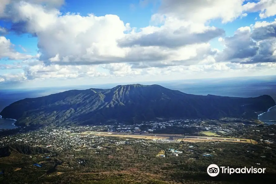
Mt. Mihara
三原山1.7
 based on 17 reviews
Recommended sightseeing time:0.5-1 day
Address:
Nakango Higashiyama, Hachijo-machi 100-1623, Tokyo PrefectureMap
What travelers say:
See all 4 photos
Recommendations Near Mt. Mihara
Mt. Mihara Reviews: Insider Insights and Visitor Experiences
Write a Review
 Trip.com
 (17 Reviews)TripAdvisor17 Reviews
You Might Also Like

Tokyo Disneyland
9.4
4.8/59162 Reviews
From £40.64
Tokyo Tower
8.1
4.7/53576 Reviews
From £6.18
Tokyo Joypolis
6.2
4.6/5170 Reviews
Save £6.18
From £19.54
Maxell Aqua Park Shinagawa
6.0
4.6/5218 Reviews
From £12.86
Nearby Attractions
Miharashi-no-Yu Hot Spring | Nambara Senjojiki | Fureai-no-Yu Hot Spring | Hotspring Foot Bath Kirameki | Sokodo Beach | Osaka Tunnel Observation Deck | Nago Observation Site | Uramigataki Hot Spring | Hattori Yashiki | Hachijojima Geothermal Energy Museum | Occhogahama Swimming Area | Okataura Park | Borawazawa Hot Spring | Hachijo Botanical Park | Kurosuna Black Sand Dunes | Ogoshihana Lighthouse | Hachijo Fuji | Karataki Waterfall | Ionuma | Izumi Water Park | Hisaichi Diver's Club | Concolor | Regulus diving | Uramiga Fall | Yokoma Beach Resort | Tomb of Fujufuseso | Uramigataki Waterfall | Hachijō-jima | Noboryo-Toge Observation Deck | Mt. Hachijo-Fuji Ohachi Meguri Course
Popular Types of Attractions in Hachijojima
Parks | City Parks | Amusement Parks | Botanical Gardens | Religious Sites | Other Places of Worship | Temples | Churches and Cathedrals | Lifestyle | Hot Springs | Entertainment Centers | Libraries | Exhibition Centers | Museums | Art Museums | Art Galleries | Architecture & Landmarks | Monuments | Featured Neighborhoods | Theaters | Historic Sites | Historical Sites | Cemeteries | Castles | Nature | Lakes | Attractions | Beaches | Popular Spots | Outdoor Sports
Popular Restaurants in Hachijojima
Restaurant Cook-San | Daikichimaru | Satoimoto Galapagos | Eight | Asokozushi | Pocket | Meidai Ikkyuan | Akakokko | Kukansha | Taimu | Green Post | Uohachitei | Shelltone Cafe | Hachijojima Jersey Cafe | Men's Club Shuchinikurin | Renge | Smile | Hamagen | Nanaya | yum.yum | Jurokuban | Genki Kunimatsu | Isozakien | Kuriya | Jizakana Himono Shokudo | Restaurant Michi | Horaiken | Nakanogo | Fujitaka | Tamura
Popular Destinations
Singapore Travel | Cupar Travel | Toronto Travel | Washington D.C. Travel | Kota Bharu Travel | Birmingham Travel | Lake District Travel | Genting Highlands Travel | Krakow Travel | Watford Travel | Southend-on-Sea Travel | Phi Phi Islands Travel | Koh Samui Travel | Manila Travel | Lleida Travel | Ramsgate Travel | Goreme Travel | Abidjan Travel | Tanger-Tetouan-Al Hoceima Travel | Lika-Senj County Travel | Nemaha County Travel | Naxos Island Travel | Great Barrington Travel | Soufriere Travel | Kuressaare Travel | Moose Jaw Travel | Ageo Travel | Burry Port Travel | Tusten Travel
Recommended Attractions at Popular Destinations
Bangkok attraction near me | Tokyo attraction near me | Manila attraction near me | Hong Kong attraction near me | Taipei attraction near me | Seoul attraction near me | Los Angeles attraction near me | New York attraction near me | Shanghai attraction near me | Kuala Lumpur attraction near me | Shenzhen attraction near me | Osaka attraction near me | Singapore attraction near me | London attraction near me | Guangzhou attraction near me | San Francisco attraction near me | Beijing attraction near me | Macau attraction near me | Bali attraction near me | Paris attraction near me | Ho Chi Minh City attraction near me | Orlando attraction near me | Jakarta attraction near me | Phuket attraction near me | Chicago attraction near me | Toronto attraction near me | Istanbul attraction near me | Dallas attraction near me | Cebu attraction near me | Seattle attraction near me
Popular Travel Types
More Things To Do in Hachijojima
Japan eSIM | SoftBank/IIJmio Unlimited 4G High Speed data(Natural day) | Asia 8 countries eSIM 4G high-speed network QR Code | Asia・Australia eSIM|AIS SIM2Fly 8 days 6GB High-speed Unlimited 5G/4G Data | Japan eSIM | Unlimited 5G high-speed data | Japan eSIM | SoftBank Unlimited 4G High Speed Data (1 day = 24 hours) | Trip.SIM Japan, South Korea, Macau, Taiwan and many places in Asia + Australia and New Zealand 4G travel data roaming phone network card 4 days/7 days | Japan 4G SIM Card (HK, Macau, Taiwan, China Delivery Only) | Global multi-region A series eSIM|High-speed data, travel and business Internet access, optional unlimited data, optional days, QR code | [Unlimited Data] Japanese 4G/5G High-speed WiFi Sharer-Hong Kong Airport Pickup (Provided by WiFiBB) | Global Regions eSIM|Unlimited 4G High Speed Data | [Japan] 4G Internet Card|CMI|Unlimited Data SIM Card|Number of Optional Days|Insert the card and use it|Self-pickup at Hong Kong Airport | [General in Asia] 4G network | Unlimited traffic | Self-pickup at the airport | WiFi rental, high-speed traffic, shared by multiple people, ready to use at boot, 12H standby, 24H customer service | Japan eSIM | KDDI, SoftBank Unlimited 4G High Speed Data | eSIM Japan by Gohub | 【Japan eSIM】Japan eSIM with Unlimited High-speed Data | Japan eSIM Data Plan QR Code | AIS SIM2Fly Global eSIM|15 days 6GB high-speed 4G/5G Unlimited Data | [Southeast Asia] 4G network | Unlimited traffic | Self-pickup at the airport | WiFi rental, high-speed traffic, shared by multiple people, ready to use at boot, 12H standby, 24H customer service | Japan eSIM high-speed traffic, travel and business Internet, days optional softbank network QR code | Global (30 Countries) eSIM Data Package (QR Code) | [South Korea] 4G network | Unlimited traffic | Self-pickup at the airport | WiFi rental, high-speed traffic, shared by multiple people, ready to use at boot, 12H standby, 24H customer service | Japan eSIM|High-speed data, travel and business Internet access, optional unlimited data, optional days, QR code | eSender- Brunei/Indonesia/Singapore/Japan and many other countries and regions eSIM daily package/data package (QR code) | [Japan] 4G Internet Card|docomo|30-day optional package|Insert the card and use it|Self-pickup at Hong Kong Airport | eSender - Japan eSIM daily package/data package (QR code) | Global eSim for 140+ countries (sent via email) by Xplori | Global multi-region C series eSIM|Common in 84 countries Travel and business Internet access Optional unlimited data Optional days QR code | AIS Global esim data package (QR code) | [Global use] 4G network | Unlimited traffic | Self-pickup at the airport | WiFi rental, high-speed traffic, shared by multiple people, ready to use at boot, 12H standby, 24H customer service | Global multi-region B series eSIM|Universal in 54 countries Travel and business Internet access Optional unlimited data Optional days QR code
Payment Methods
Our Partners
Copyright © 2024 Trip.com Travel Singapore Pte. Ltd. All rights reserved
Site Operator: Trip.com Travel Singapore Pte. Ltd.
Site Operator: Trip.com Travel Singapore Pte. Ltd.
Great hike!
A beautiful, not very demanding hike! At the top you can barely see the caldera, you have a beautiful view of the town and mount Nishi. On the way back there is a waterfall with salamanders in the pon...
Have a fun hike to the top, and behold the beautiful crater
I can't drive so I decided to hike all the way from the town right to the top of the crater and back. Took me the best part of the day but I had a great time and I'm sure it gave my legs a fantastic w...
360 degree view
You can turn along the TEPCO Power Station fence and stop 3 ~ 4 parking lots at the road leading to the second three-way radio tower and barricade. The radio tower is a wide concrete road, then the stairs continue to the ridge, and after that, the top of the station 々 stairs will pass through the transmission tower of NHK. Airport and runway Hachijojima Fuji Bottom Port Hachijojima City Hachijojima Kojima is. I can.
the shape of the mountain is better than hachijo fuji.
Mt. Mihara is located in the south of Hachijo Island, and there is a town between Hachijo Fuji in the north, and most people live there. Altitude 700.9m. I looked good from Hachijo Fuji. The scenery is not good because the shape of the mountain is not good. It is Mt. Mihara seen from the famous observatory. It was a normal mountain and the scenery was not a big deal.
The view of Mt. Mihara from Hachijo Fuji is good.
I am looking out for Mt. Mihara. Mt. Mihara is a low mountain on Hachijo Island. In the west of Mt. Mihara (left in this photo), there are no houses and you can't reach your mobile phone. I wanted to go to the Toryu Pass Observatory, where I could see Mt. Mihara from the west, but ... I turned from the east and made a U-turn at Hachijojima Lighthouse. I could see Mt. Mihara from the nearby Meiko observatory, but the scenery was not so good.