OverviewNearbyReviewsWin PrizesRecommended
Share to
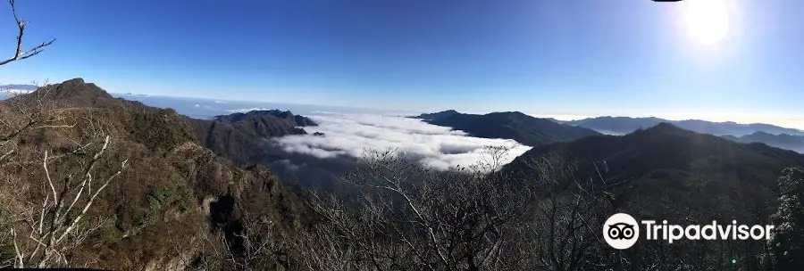
Mt. Shojidake
障子岳1.0
 based on 1 review
Address:
Ogatamachi Ohira South of Mt. Sobo, Kawakami Valley, Bungoono 879-7100 Oita PrefectureMap
What travelers say:
See all 2 photos
Recommendations Near Mt. Shojidake
Mt. Shojidake Reviews: Insider Insights and Visitor Experiences
Write a Review
 Trip.com
 (1 Reviews)TripAdvisor1 Review
You Might Also Like

Oita Fragrance Museum
2.9
4.9/513 Reviews
From £4.42
Fukuoka Tower
6.5
4.5/5591 Reviews
From £4.07
Kyushu National Museum
4.9
4.6/596 Reviews
Marine World
5.8
4.6/5137 Reviews
From £12.19
Nearby Attractions
Takachiho Gorge | Takachiho Shrine | Amanoiwato Shrine | Mount Aso | Amanoyasukawara | Amaterasu Railway | Aratate Shrine | Aso Nakadake Crater 1 | Kushifuru Shrine | Akimoto Shrine | Takachihogamadase Market | Futagami Shrine | Takachiho Kagura | Kamishikimi Kumanoimasu Shrine | Shirakawa Spring | Takachiho General Park | Kunimigaoka | Heitate Shrine | Takachiho Gorge Aquarium | Goketsushokogen Sanshudaihimeyuri Park | Takamori Yusui Tunnel Park | Manaino Falls | Tsūjun Bridge | Isshingyo Sakura Tree | Kunimigaoka Viewing Platform | Tamadare Falls | Aso Sanjo Public Square | Tsukimawari Spa | Aso Hakusui Ryujin-gongen (Shirohebi Shrine) | Statue of Franky
Popular Types of Attractions in Takachiho
Parks | City Parks | Botanical Gardens | Zoos | Exhibition Centers | Museums | Art Museums | Art Galleries | Religious Sites | Other Places of Worship | Temples | Churches and Cathedrals | Architecture & Landmarks | Monuments | Observation Decks | landmark | Lifestyle | Hot Springs | Resorts | Spas | Popular Spots | Historic Sites | Historical Sites | Castles | Cemeteries | Nature | Attractions | Lakes | Mountains | Fitness
Popular Restaurants in Takachiho
Kihachi Chaya | Hanakobo | Cafe Arigato | Neko no Shippo | Jindai-An | Otaniya | Araragi No Chaya | Tanohana | Marazontei | Furusatosabo Ishinokura | Inaba Saketen | Onokoro Chaya | Takachiho Sweets Cafe Ansoreiyu | Manai | Asuka Ramen | Meat Workshop Hatsuei | Mori No Kitchen | Kenchan | Joyfull | Kutsurogidokoro Shintei | Restaurant Bar Cats | Kagura Yado | Tanpopoya | Izakaya Tentsukuten | Chiho no Ie | Gokoku | Shunsaikushiage Mugamuchu | Cafe Terrace Takachihoya | Cafe Merchen | Sumibiyaki Zipangu
Popular Destinations
Hersonissos Travel | Dhaka Travel | Cape Town Travel | Guilin Travel | Bucharest Travel | Lanzarote Travel | Wellingborough Travel | Lijiang Travel | Exeter Travel | Islamabad Travel | Jakarta Travel | Greece Travel | England Travel | Wolverhampton Travel | Darlington Travel | Cagliari Travel | Torremolinos Travel | Hawaii-Maui Travel | Montego Bay Travel | Nova Scotia Travel | Kakadu National Park Travel | New York State Travel | Oakland Travel | Albury City Council Travel | Georgetown Travel | Arlanza Travel | Port Erin Travel | Nelson Travel | Hyogo Prefecture Travel
Recommended Attractions at Popular Destinations
Bangkok attraction near me | Tokyo attraction near me | Manila attraction near me | Hong Kong attraction near me | Taipei attraction near me | Seoul attraction near me | Los Angeles attraction near me | New York attraction near me | Shanghai attraction near me | Kuala Lumpur attraction near me | Shenzhen attraction near me | Osaka attraction near me | Singapore attraction near me | London attraction near me | Guangzhou attraction near me | San Francisco attraction near me | Beijing attraction near me | Macau attraction near me | Bali attraction near me | Paris attraction near me | Ho Chi Minh City attraction near me | Orlando attraction near me | Jakarta attraction near me | Phuket attraction near me | Chicago attraction near me | Toronto attraction near me | Fukuoka attraction near me | Istanbul attraction near me | Dallas attraction near me | Cebu attraction near me
Popular Trip Moments
Takachiho Shrine 🇯🇵 | Takachiho Gorge's Delightful and Tasty Flowing Noodles | Kitakyushu | Tour Takachiho Gorge and view the Manai Falls | Kitakyushu | Tourist Sightseeing Train - Takachiho Station | 【A Must-Visit Waterfall Spot】Takachiho Gorge. | Paradise on Earth | Takachiho Gorge | Enjoy the scenic autumn leaves and private hot springs with Kengo Kuma in Kyushu | Takachiho gorge 🤩 | 📍 Takachiho Gorge, Japan 🇯🇵 | Feeling tired lately? These healing places are worth a visit | Awesome view at Takachiho Gorge | Takachiho Gorge
Popular Travel Types
More Things To Do in Takachiho
Miyazaki Takachiho Gorge + Amano Iwato Shrine Day Tour [Round Two-way Bus | Depart from Fukuoka | Lunch Included] | One-day chartered car tour to Fukuoka/Kumamoto/Mt. Aso/Miyazaki/Oita/Beppu/Itoshima in Kyushu, Japan (optional Chinese/English/Korean driver/hotel pick-up/customizable itinerary) | Japan Miyazaki Takachiho Gorge + Kamishiromi Kumanoza Shrine Day Tour [Lunch included / the beauty of Manai Waterfall / Amano Iwato Shrine] | Fukuoka/Kumamoto/Mt. Aso/Miyazaki/Oita/Beppu/Itoshima/Kitakyushu chartered one-day tour (Chinese-speaking driver/hotel pick-up/customizable itinerary) | Day Trip Charter Bus Tour to Mythical "Takachiho" from Fukuoka | Japan eSIM | SoftBank/IIJmio Unlimited 4G High Speed data(Natural day) | Asia 8 countries eSIM 4G high-speed network QR Code | Asia・Australia eSIM|AIS SIM2Fly 8 days 6GB High-speed Unlimited 5G/4G Data | Japan eSIM | SoftBank Unlimited 4G High Speed Data (1 day = 24 hours) | Japan eSIM | Unlimited 5G high-speed data | Trip.SIM Japan, South Korea, Macau, Taiwan and many places in Asia + Australia and New Zealand 4G travel data roaming phone network card 4 days/7 days | Japan 4G SIM Card (HK, Macau, Taiwan, China Delivery Only) | Global multi-region A series eSIM|High-speed data, travel and business Internet access, optional unlimited data, optional days, QR code | Japan Fukuoka Kumamoto Castle + Aso Nakadake Crater Day Tour [Lunch included | Optional Chartered Vehicle| Kamishiro-mi Kumanoza Shrine | Let's go to Aso] | Global Regions eSIM|Unlimited 4G High Speed Data | Japan+Kumamoto+Kusasenri+Mt. Aso+Kikuchi Park one-day tour [Classic Kumamoto one-day tour+Chinese car transfer+Itinerary can be flexible] | Japan Oita Yufuin Street + Beppu Hell Day Tour [Bus Tour | See the Hell Hot Springs | Upgrade to Private Chartered Vehicle| Optional Pickup] | [General in Asia] 4G network | Unlimited traffic | Self-pickup at the airport | WiFi rental, high-speed traffic, shared by multiple people, ready to use at boot, 12H standby, 24H customer service | Kumamoto Half-Day Private Tour with Government-Licensed Guide | One-day tour to Kyushu Natural Animal Park in Oita, Japan [Natural Park + Yufuin] | Global eSIM 4G/5G high-speed network QR code | Japan + Kumamoto + Kokonoe "Dream" Suspension Bridge + Yufuin Kinrinko Art Museum + Yufuin Hot Spring One-day Tour [Suspension Bridge Tour + Art Museum + Millennium Hot Spring Soaking + Chinese Private Car Transfer] | Japan eSIM high-speed traffic, travel and business Internet, days optional softbank network QR code | Japan + Kumamoto + Kokonoe "Dream" Suspension Bridge + Mount Aso + Kinrin Lake One-day Tour [Soak in Millennium Hot Spring + Taste Hot Spring Soft-boiled Eggs + Tenzu Shrine + Chinese Private Car Transfer] | Hot Spring Capital of Yufuin Rickshaw Tour | Japan eSIM|High-speed data, travel and business Internet access, optional unlimited data, optional days, QR code | Japan Fukuoka + Mt. Aso One-Day Tour [Kamiishiki Kumanoza Shrine|Mt. Aso|Kurokawa Onsen [Monday/Wednesday/Friday]] | Japan+Kumamoto+Sakura Nobaba Castle Castle Garden+Kumamoto Castle+Zhirenkan Inari Shrine+Kumamoto Minister’s Office+Katsuretsu Tei One-Day Tour [Kumamoto One-day Tour Chinese-speaking Private Car Transfer] | Charter Bus Transfer for Rafting to Kuma River from Fukuoka | 【Japan eSIM】Japan eSIM with Unlimited High-speed Data
Payment Methods
Our Partners
Copyright © 2024 Trip.com Travel Singapore Pte. Ltd. All rights reserved
Site Operator: Trip.com Travel Singapore Pte. Ltd.
Site Operator: Trip.com Travel Singapore Pte. Ltd.
Mt. somoyama is located in the mountain system of Takeda City, Oita Prefecture and Miyazaki Prefecture, and the southeast ridge system has Tengu rock, Shoji rock, Shoji Dake, and Mt. kosomoyama, and it is connected to the mountain in the East. The ridge system from Mt. soma to the northeast is called Shoji ridge and is connected to the large Shoji rock and the former Shoji. Between these two ridges, there is Kawakami Valley, and the valley becomes a horseshoe type by both ridges, and the Taniguchi has the former Ohira mine site and the mountaineering gate. Along with the Kuju mountain range, the grandmother, the mountain system, is the best mountain climbing point in Kyushu. ...